
Carte topographique Kittson County
Carte interactive
Cliquez sur la carte pour afficher l’altitude.
À propos de cette carte
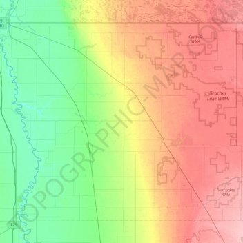
Nom : Carte topographique Kittson County, altitude, relief.
Lieu : Kittson County, Minnesota, United States (48.54326 -97.23926 49.00050 -96.38699)
Altitude moyenne : 275 m
Altitude minimum : 233 m
Altitude maximum : 334 m
Kittson County was once part of glacial Lake Agassiz. Evidence of this prehistoric lake can still be seen in the county's topography. Remnants of McCauleyville Beach can be found in the eastern part of the county, an area of sandy soil and sand ridges. Other evidence of the glacier and Lake Agassiz is the approximately 140' drop in elevation from the eastern part of the county to the western part, near the Red River Valley, with its proliferation of black rich soil. Lake Bronson is a manmade reservoir, completed in 1937.
Autres cartes topographiques
Cliquez sur une carte pour visualiser sa topographie, son altitude et son relief.
Minneapolis
United States > Minnesota > Hennepin County
Minneapolis, Hennepin County, Minnesota, United States
Altitude moyenne : 270 m
Saint Paul
United States > Minnesota > Ramsey County
Saint Paul, Ramsey County, Minnesota, United States
Altitude moyenne : 268 m
Bloomington
United States > Minnesota > Hennepin County
Bloomington, Hennepin County, Minnesota, United States
Altitude moyenne : 255 m
Bucks Mill
United States > Minnesota > Becker County
Bucks Mill, Becker County, Minnesota, United States
Altitude moyenne : 410 m
Maple Grove
United States > Minnesota > Hennepin County
Maple Grove, Hennepin County, Minnesota, United States
Altitude moyenne : 278 m
Duluth
United States > Minnesota > Saint Louis County
Duluth, Saint Louis County, Minnesota, United States
Altitude moyenne : 286 m
Big Moose Lake
United States > Minnesota > Saint Louis County
Big Moose Lake, Northeast St Louis, Saint Louis County, Minnesota, United States
Altitude moyenne : 432 m
Minneapolis
United States > Minnesota > Hennepin County > Minneapolis
Minneapolis, Hennepin County, Minnesota, 55488, United States
Altitude moyenne : 271 m
Rochester
United States > Minnesota > Olmsted County
Rochester, Olmsted County, Minnesota, United States
Altitude moyenne : 354 m
Itasca County
Itasca County, Minnesota, United States
Altitude moyenne : 412 m
Mankato
United States > Minnesota > Blue Earth County
Mankato, Blue Earth County, Minnesota, 56001, United States
Altitude moyenne : 285 m
Olmsted County
Olmsted County, Minnesota, United States
Altitude moyenne : 354 m
Crow Wing County
Crow Wing County, Minnesota, United States
Altitude moyenne : 386 m
Eagan
United States > Minnesota > Dakota County
Eagan, Dakota County, Minnesota, United States
Altitude moyenne : 267 m
Bonnevista Terrace Mobile Home Park
United States > Minnesota > Scott County
Bonnevista Terrace Mobile Home Park, Jackson Township, Scott County, Minnesota, United States
Altitude moyenne : 241 m
Washington County
Washington County, Minnesota, United States
Altitude moyenne : 283 m
Hills
United States > Minnesota > Rock County
Hills, Martin Township, Rock County, Minnesota, 56138, United States
Altitude moyenne : 445 m
Green Lake
United States > Minnesota > Beltrami County > Little Rock
Green Lake, Little Rock, Beltrami County, Minnesota, United States
Altitude moyenne : 379 m
Grey Cloud Island
United States > Minnesota > Washington County > Grey Cloud Island Township
Grey Cloud Island, Grey Cloud Island Township, Washington County, Minnesota, 55071, United States
Altitude moyenne : 225 m
West St. Paul
United States > Minnesota > Dakota County
West St. Paul, Dakota County, Minnesota, 55118, United States
Altitude moyenne : 294 m
Bemidji
United States > Minnesota > Beltrami County
Bemidji, Beltrami County, Minnesota, 56601, United States
Altitude moyenne : 417 m
Dunnell
United States > Minnesota > Martin County
Dunnell, Martin County, Minnesota, United States
Altitude moyenne : 403 m
Gainy Park
United States > Minnesota > Steele County > Owatonna
Gainy Park, Owatonna, Steele County, Minnesota, United States
Altitude moyenne : 359 m
Glendale
United States > Minnesota > Scott County > Savage
Glendale, Savage, Scott County, Minnesota, 55378, United States
Altitude moyenne : 262 m
Sherburne County
Sherburne County, Minnesota, United States
Altitude moyenne : 298 m
Stillwater
United States > Minnesota > Washington County
Stillwater, Washington County, Minnesota, United States
Altitude moyenne : 259 m
Big Deep Lake
United States > Minnesota > Cass County
Big Deep Lake, Cass County, Minnesota, United States
Altitude moyenne : 420 m
Bodum
United States > Minnesota > Isanti County
Bodum, Isanti Township, Isanti County, Minnesota, 55008, United States
Altitude moyenne : 294 m
Oxlip
United States > Minnesota > Isanti County
Oxlip, Bradford Township, Isanti County, Minnesota, United States
Altitude moyenne : 288 m
Minnetonka
United States > Minnesota > Hennepin County
Minnetonka, Hennepin County, Minnesota, United States
Altitude moyenne : 290 m
Crown
United States > Minnesota > Isanti County
Crown, Stanford Township, Isanti County, Minnesota, United States
Altitude moyenne : 295 m
Weber
United States > Minnesota > Isanti County
Weber, North Branch Township, Isanti County, Minnesota, United States
Altitude moyenne : 282 m
Walbo
United States > Minnesota > Isanti County
Walbo, Springvale Township, Isanti County, Minnesota, United States
Altitude moyenne : 286 m
Springvale
United States > Minnesota > Isanti County
Springvale, Springvale Township, Isanti County, Minnesota, United States
Altitude moyenne : 288 m
Pine Brook
United States > Minnesota > Isanti County
Pine Brook, Springvale Township, Isanti County, Minnesota, United States
Altitude moyenne : 291 m
Grandy
United States > Minnesota > Isanti County
Grandy, Cambridge Township, Isanti County, Minnesota, 55029, United States
Altitude moyenne : 285 m
Elm Park
United States > Minnesota > Isanti County
Elm Park, Maple Ridge Township, Isanti County, Minnesota, United States
Altitude moyenne : 290 m
Carmody
United States > Minnesota > Isanti County
Carmody, Dalbo Township, Isanti County, Minnesota, 55017, United States
Altitude moyenne : 299 m
Stanchfield
United States > Minnesota > Isanti County
Stanchfield, Stanchfield Township, Isanti County, Minnesota, 55080, United States
Altitude moyenne : 287 m
Wyanett
United States > Minnesota > Isanti County
Wyanett, Wyanett Township, Isanti County, Minnesota, United States
Altitude moyenne : 293 m
West Point
United States > Minnesota > Isanti County
West Point, Spencer Brook Township, Isanti County, Minnesota, United States
Altitude moyenne : 287 m
Stanley
United States > Minnesota > Isanti County
Stanley, Isanti Township, Isanti County, Minnesota, United States
Altitude moyenne : 293 m
Stanchfield Corner
United States > Minnesota > Isanti County
Stanchfield Corner, Stanchfield Township, Isanti County, Minnesota, 55080, United States
Altitude moyenne : 287 m
Spring Lake
United States > Minnesota > Isanti County
Spring Lake, North Branch Township, Isanti County, Minnesota, United States
Altitude moyenne : 286 m
Spencer Brook
United States > Minnesota > Isanti County
Spencer Brook, Spencer Brook Township, Isanti County, Minnesota, United States
Altitude moyenne : 289 m
Edgewood
United States > Minnesota > Isanti County
Edgewood, Isanti Township, Isanti County, Minnesota, 55008, United States
Altitude moyenne : 289 m
Day
United States > Minnesota > Isanti County
Day, Maple Ridge Township, Isanti County, Minnesota, United States
Altitude moyenne : 302 m
Dalbo
United States > Minnesota > Isanti County
Dalbo, Dalbo Township, Isanti County, Minnesota, 55017, United States
Altitude moyenne : 296 m
Blomford
United States > Minnesota > Isanti County
Blomford, Isanti Township, Isanti County, Minnesota, United States
Altitude moyenne : 290 m