
Carte topographique Hills
Carte interactive
Cliquez sur la carte pour afficher l’altitude.
À propos de cette carte
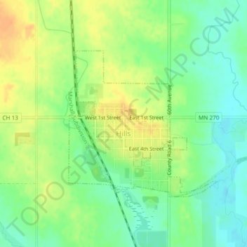
Nom : Carte topographique Hills, altitude, relief.
Altitude moyenne : 445 m
Altitude minimum : 429 m
Altitude maximum : 463 m
According to the United States Census Bureau, the city has a total area of 0.54 square miles (1.40 km2); 0.53 square miles (1.37 km2) is land and 0.01 square miles (0.03 km2) is water. The landscape is flat with some gently rolling hills; however, the town's name does not derive from a particular topographical feature. The town includes two parks, Jacobson Park and the Rez. The Rez is a man made reservoir that is used for swimming, fishing and outdoor recreation. A gravel path circles the Rez (reservoir) and there are two small playgrounds. Multiple campsites and a cabin are also on the property as well as a disc golf course.
Autres cartes topographiques
Cliquez sur une carte pour visualiser sa topographie, son altitude et son relief.
Hardwick
United States > Minnesota > Rock County
Hardwick, Rock County, Minnesota, 56134, United States
Altitude moyenne : 490 m