
Carte topographique Budapest
Carte interactive
Cliquez sur la carte pour afficher l’altitude.
À propos de cette carte
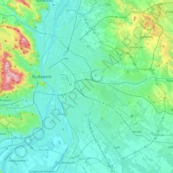
Nom : Carte topographique Budapest, altitude, relief.
Lieu : Budapest, Central Hungary, Hungary (47.34969 18.92511 47.61315 19.33493)
Altitude moyenne : 153 m
Altitude minimum : 89 m
Altitude maximum : 512 m
The wide Danube was always fordable at this point because of a small number of islands in the middle of the river. The city has marked topographical contrasts: Buda is built on the higher river terraces and hills of the western side, while the considerably larger Pest spreads out on a flat and featureless sand plain on the river's opposite bank. Pest's terrain rises with a slight eastward gradient, so the easternmost parts of the city lie at the same altitude as Buda's smallest hills, notably Gellért Hill and Castle Hill.
Autres cartes topographiques
Cliquez sur une carte pour visualiser sa topographie, son altitude et son relief.
Óbudai-sziget
Óbudai-sziget, 3rd district, Budapest, Central Hungary, Hungary
Altitude moyenne : 106 m
1st district
1st district, Budapest, Central Hungary, Hungary
Altitude moyenne : 137 m
18th district
18th district, Budapest, Central Hungary, Hungary
Altitude moyenne : 127 m
2nd district
2nd district, Budapest, Central Hungary, Hungary
Altitude moyenne : 252 m
8th district
8th district, Budapest, Central Hungary, Hungary
Altitude moyenne : 115 m
11th district
11th district, Budapest, Central Hungary, Hungary
Altitude moyenne : 139 m
14th district
14th district, Budapest, Central Hungary, Hungary
Altitude moyenne : 116 m
12th district
12th district, Budapest, Central Hungary, Hungary
Altitude moyenne : 267 m
9th district
9th district, Budapest, Central Hungary, Hungary
Altitude moyenne : 113 m
Hűvösvölgy
Hűvösvölgy, 2nd district, Budapest, Central Hungary, Hungary
Altitude moyenne : 274 m
Kelenvölgy
Kelenvölgy, 11th district, Budapest, Central Hungary, 1514, Hungary
Altitude moyenne : 120 m
János-hegy
János-hegy, Budapest, Central Hungary, 1021, Hungary
Altitude moyenne : 343 m
Gellért Hill
Gellért Hill, Budapest, Central Hungary, 1114, Hungary
Altitude moyenne : 126 m
Hármashatárhegy
Hármashatárhegy, 3rd district, Budapest, Central Hungary, Hungary
Altitude moyenne : 291 m
Margaret Island
Margaret Island, Budapest, Central Hungary, 1007, Hungary
Altitude moyenne : 115 m
4th district
4th district, Budapest, Central Hungary, Hungary
Altitude moyenne : 111 m