
Carte topographique 8th district
Carte interactive
Cliquez sur la carte pour afficher l’altitude.
À propos de cette carte
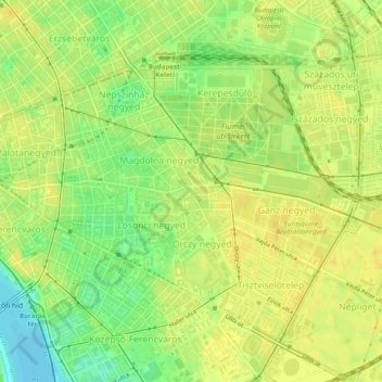
Nom : Carte topographique 8th district, altitude, relief.
Lieu : 8th district, Budapest, Central Hungary, Hungary (47.47562 19.05997 47.50199 19.10907)
Altitude moyenne : 115 m
Altitude minimum : 100 m
Altitude maximum : 122 m
Autres cartes topographiques
Cliquez sur une carte pour visualiser sa topographie, son altitude et son relief.
Óbudai-sziget
Óbudai-sziget, 3rd district, Budapest, Central Hungary, Hungary
Altitude moyenne : 106 m
1st district
1st district, Budapest, Central Hungary, Hungary
Altitude moyenne : 137 m
18th district
18th district, Budapest, Central Hungary, Hungary
Altitude moyenne : 127 m
2nd district
2nd district, Budapest, Central Hungary, Hungary
Altitude moyenne : 252 m
11th district
11th district, Budapest, Central Hungary, Hungary
Altitude moyenne : 139 m
14th district
14th district, Budapest, Central Hungary, Hungary
Altitude moyenne : 116 m
12th district
12th district, Budapest, Central Hungary, Hungary
Altitude moyenne : 267 m
9th district
9th district, Budapest, Central Hungary, Hungary
Altitude moyenne : 113 m
Hűvösvölgy
Hűvösvölgy, 2nd district, Budapest, Central Hungary, Hungary
Altitude moyenne : 274 m
Kelenvölgy
Kelenvölgy, 11th district, Budapest, Central Hungary, 1514, Hungary
Altitude moyenne : 120 m
János-hegy
János-hegy, Budapest, Central Hungary, 1021, Hungary
Altitude moyenne : 343 m
Gellért Hill
Gellért Hill, Budapest, Central Hungary, 1114, Hungary
Altitude moyenne : 126 m
Hármashatárhegy
Hármashatárhegy, 3rd district, Budapest, Central Hungary, Hungary
Altitude moyenne : 291 m
Margaret Island
Margaret Island, Budapest, Central Hungary, 1007, Hungary
Altitude moyenne : 115 m
4th district
4th district, Budapest, Central Hungary, Hungary
Altitude moyenne : 111 m