
Carte topographique La Ferté-en-Ouche
Carte interactive
Cliquez sur la carte pour afficher l’altitude.
À propos de cette carte
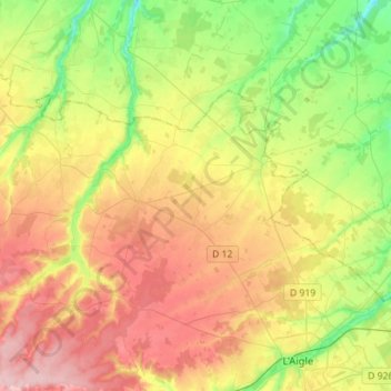
Nom : Carte topographique La Ferté-en-Ouche, altitude, relief.
Altitude moyenne : 241 m
Altitude minimum : 166 m
Altitude maximum : 329 m
Autres cartes topographiques
Cliquez sur une carte pour visualiser sa topographie, son altitude et son relief.
Coulonges-sur-Sarthe
Coulonges-sur-Sarthe, Alençon, Orne, Normandie, France métropolitaine, 61170, France
Altitude moyenne : 168 m
La Genevraie
La Genevraie, Mortagne-au-Perche, Orne, Normandie, France métropolitaine, 61240, France
Altitude moyenne : 240 m
La Villette
France > Normandie > Orne > Avoine
La Villette, Avoine, Argentan, Orne, Normandie, France métropolitaine, 61150, France
Altitude moyenne : 181 m