
Faire un don
Équipez-vous pour votre prochaine aventure :
En tant que Partenaire Amazon, ce site perçoit une commission sur les achats éligibles sans surcoût pour vous.
Carte topographique Sturgeon Lake
Cliquez sur la carte pour afficher l’altitude.
Équipez-vous pour votre prochaine aventure :
En tant que Partenaire Amazon, ce site perçoit une commission sur les achats éligibles sans surcoût pour vous.
Sturgeon Lake
Sturgeon Lake is a lake in north-western Alberta, Canada. It has a total area of 49.1 km2 (19.0 sq mi) and a maximum depth of 9.5 m (31 ft). It is located in the hydrographic basin of the Little Smoky River at an elevation of 685 m, 20 km west of the town of Valleyview, along Highway 43.
Faire un don
Équipez-vous pour votre prochaine aventure :
En tant que Partenaire Amazon, ce site perçoit une commission sur les achats éligibles sans surcoût pour vous.
À propos de cette carte
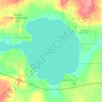
Nom : Carte topographique Sturgeon Lake, altitude, relief.
Altitude moyenne : 696 m
Altitude minimum : 669 m
Altitude maximum : 759 m
Faire un don
Équipez-vous pour votre prochaine aventure :
En tant que Partenaire Amazon, ce site perçoit une commission sur les achats éligibles sans surcoût pour vous.
Autres cartes topographiques
Cliquez sur une carte pour visualiser sa topographie, son altitude et son relief.
Banff
Canada > Alberta > Banff > Banff
Banff is a town within Banff National Park in Alberta, Canada. It is located in Alberta's Rockies along the Trans-Canada Highway, approximately 126 km (78 mi) west of Calgary and 58 km (36 mi) east of Lake Louise. At 1,400 to 1,630 m (4,590 to 5,350 ft) above sea level, Banff is the community with the second…
Altitude moyenne : 1 615 m
Nose Hill Park
Names currently associated with topographical features in and near Nose Hill Park reflect the impact of the European newcomers and European trade goods on the Peigan. For example, Spy Hill, the westward extension of Nose Hill, derived its present name from the aboriginal practice of communicating with distant…
Altitude moyenne : 1 174 m
Grande Prairie
Canada > Alberta > Grande Prairie
Grande Prairie is located just north of the 55th parallel north, and is 465 km (289 mi) northwest of Edmonton, lying at an elevation of 669 m (2,195 ft) above sea level. The city is surrounded by farmland to the north, east, and west. To the south lies a vast boreal forest with aspen, tamarack, lodgepole pine,…
Altitude moyenne : 668 m
Faire un don
Équipez-vous pour votre prochaine aventure :
En tant que Partenaire Amazon, ce site perçoit une commission sur les achats éligibles sans surcoût pour vous.
Lethbridge
Canada > Alberta > Lethbridge
Its high elevation of 929 m (3,047.9 ft) and close proximity to the Rocky Mountains provides Lethbridge with cooler summers than other locations in the Canadian Prairies. These factors protect the city from strong northwest and southwest winds and contribute to frequent chinook winds during the winter.…
Altitude moyenne : 918 m
Faire un don
Équipez-vous pour votre prochaine aventure :
En tant que Partenaire Amazon, ce site perçoit une commission sur les achats éligibles sans surcoût pour vous.
Lake Louise
Canada > Alberta > Improvement District No. 9
Lake Louise is a hamlet within Banff National Park in Alberta, Canada. Named after Princess Louise, Duchess of Argyll, it lies in Alberta's Rockies on the Bow River, 3 km (1.9 mi) northeast of the lake that shares its name. Initially settled in 1884 as an outpost for the Canadian Pacific Railway, Lake Louise…
Altitude moyenne : 1 617 m
Cochrane
Canada > Alberta > Town of Cochrane > Cochrane
Cochrane is situated at the base of Big Hill in the Bow River Valley. It sits at an elevation of 1,186 m (3,891 ft). The town is intersected by Highway 1A and Highway 22. Cochrane has a reputation for its western culture, which can easily be felt when one wanders the streets (particularly Main Street). The…
Altitude moyenne : 1 205 m
Canmore
Canada > Alberta > Town of Canmore
Elevation Place opened in April 2013 as Canmore's new recreation facility. Construction of the facility began in 2012 to replace the Canmore Recreation Centre (the community's old facility). The facility offers an 8-lane 25m lap pool, a world class climbing wall developed by Walltopia, two cardio rooms, a…
Altitude moyenne : 1 565 m
Faire un don
Équipez-vous pour votre prochaine aventure :
En tant que Partenaire Amazon, ce site perçoit une commission sur les achats éligibles sans surcoût pour vous.
West Bragg Creek Provincial Recreation Area
Canada > Alberta > Kananaskis Improvement District
Altitude moyenne : 1 467 m
Faire un don
Équipez-vous pour votre prochaine aventure :
En tant que Partenaire Amazon, ce site perçoit une commission sur les achats éligibles sans surcoût pour vous.
Peace River
Canada > Alberta > Peace River
Physiographically, the Town of Peace River lies within the Peace River Formation, a stratigraphical unit of middle Albian age in the Western Canadian Sedimentary Basin. The area developed on sediments of the former lake bottom of Glacial Lake Peace, which covered most of the areas in the region that were below…
Altitude moyenne : 433 m
Faire un don
Équipez-vous pour votre prochaine aventure :
En tant que Partenaire Amazon, ce site perçoit une commission sur les achats éligibles sans surcoût pour vous.
Nordegg
Canada > Alberta > Clearwater County
Nordegg has a subarctic climate (Dfc) which can be considered a subalpine climate due to its altitude with locations on the same latitude having warmer climates. Summers are mild, with a few warm days sprinkled in here and there, while winters are cold and snowy.
Altitude moyenne : 1 475 m
Faire un don
Équipez-vous pour votre prochaine aventure :
En tant que Partenaire Amazon, ce site perçoit une commission sur les achats éligibles sans surcoût pour vous.
Faire un don
Équipez-vous pour votre prochaine aventure :
En tant que Partenaire Amazon, ce site perçoit une commission sur les achats éligibles sans surcoût pour vous.
Faire un don
Équipez-vous pour votre prochaine aventure :
En tant que Partenaire Amazon, ce site perçoit une commission sur les achats éligibles sans surcoût pour vous.
Faire un don
Équipez-vous pour votre prochaine aventure :
En tant que Partenaire Amazon, ce site perçoit une commission sur les achats éligibles sans surcoût pour vous.
Mount Columbia
Canada > Alberta > Improvement District No. 12
Mount Columbia is a mountain located in the Winston Churchill Range of the Rocky Mountains. It is the highest point in Alberta, Canada, and is second only to Mount Robson for height and topographical prominence in the Canadian Rockies. It is located on the border between Alberta and British Columbia on the…
Altitude moyenne : 2 841 m
Faire un don
Équipez-vous pour votre prochaine aventure :
En tant que Partenaire Amazon, ce site perçoit une commission sur les achats éligibles sans surcoût pour vous.
Faire un don
Équipez-vous pour votre prochaine aventure :
En tant que Partenaire Amazon, ce site perçoit une commission sur les achats éligibles sans surcoût pour vous.
Marten Beach Subdivision
Canada > Alberta > Municipal District of Lesser Slave River
Altitude moyenne : 585 m
Faire un don
Équipez-vous pour votre prochaine aventure :
En tant que Partenaire Amazon, ce site perçoit une commission sur les achats éligibles sans surcoût pour vous.
Faire un don
Équipez-vous pour votre prochaine aventure :
En tant que Partenaire Amazon, ce site perçoit une commission sur les achats éligibles sans surcoût pour vous.
Faire un don
Équipez-vous pour votre prochaine aventure :
En tant que Partenaire Amazon, ce site perçoit une commission sur les achats éligibles sans surcoût pour vous.
Nordegg
Canada > Alberta > Clearwater County
Nordegg has a subarctic climate (Dfc) which can be considered a subalpine climate due to its altitude with locations on the same latitude having warmer climates. Summers are mild, with a few warm days sprinkled in here and there, while winters are cold and snowy.
Altitude moyenne : 1 475 m
Faire un don
Équipez-vous pour votre prochaine aventure :
En tant que Partenaire Amazon, ce site perçoit une commission sur les achats éligibles sans surcoût pour vous.
Moraine Lake
Canada > Alberta > Improvement District No. 9
Moraine Lake is a snow and glacially fed alpine lake in Banff National Park, 14 kilometres (8.7 mi) outside the village of Lake Louise, Alberta, Canada. It is situated in the Valley of the Ten Peaks, at an elevation of approximately 1,884 metres (6,181 ft). The lake has a surface area of 50 hectares (120…
Altitude moyenne : 2 101 m
Faire un don
Équipez-vous pour votre prochaine aventure :
En tant que Partenaire Amazon, ce site perçoit une commission sur les achats éligibles sans surcoût pour vous.
Faire un don
Équipez-vous pour votre prochaine aventure :
En tant que Partenaire Amazon, ce site perçoit une commission sur les achats éligibles sans surcoût pour vous.
Johnston Creek
Canada > Alberta > Improvement District No. 9
Johnston Creek originates north of Castle Mountain in a glacial valley southwest of Badger Pass and south of Pulsatilla Pass, at an elevation of 2,500 meters (8,200 ft). The creek flows southeast between Helena Ridge and the Sawback Range, and then south through a gorge known as Johnston Canyon. The stream…
Altitude moyenne : 2 135 m
Faire un don
Équipez-vous pour votre prochaine aventure :
En tant que Partenaire Amazon, ce site perçoit une commission sur les achats éligibles sans surcoût pour vous.
Lake Louise
Canada > Alberta > Improvement District No. 9
Lake Louise is a hamlet within Banff National Park in Alberta, Canada. Named after Princess Louise, Duchess of Argyll, it lies in Alberta's Rockies on the Bow River, 3 km (1.9 mi) northeast of the lake that shares its name. Initially settled in 1884 as an outpost for the Canadian Pacific Railway, Lake Louise…
Altitude moyenne : 1 617 m
Bow Peak
Canada > Alberta > Improvement District No. 9
Bow Peak is a 2,840-metre (9,320-foot) mountain summit located in the Bow River valley of Banff National Park, in the Canadian Rockies of Alberta, Canada. Its nearest higher peak is Crowfoot Mountain, 2.11 km (1.31 mi) to the east. Bow Peak is situated north of Hector Lake, southeast of Bow Lake, and can be…
Altitude moyenne : 2 332 m
Faire un don
Équipez-vous pour votre prochaine aventure :
En tant que Partenaire Amazon, ce site perçoit une commission sur les achats éligibles sans surcoût pour vous.