
Carte topographique Korogwe
Carte interactive
Cliquez sur la carte pour afficher l’altitude.
À propos de cette carte
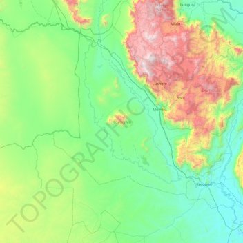
Nom : Carte topographique Korogwe, altitude, relief.
Lieu : Korogwe, Tanga Region, Northern Zone, Tanzania (-5.37250 37.90308 -4.49389 38.76912)
Altitude moyenne : 747 m
Altitude minimum : 262 m
Altitude maximum : 2 293 m
Autres cartes topographiques
Cliquez sur une carte pour visualiser sa topographie, son altitude et son relief.
Kwai
Kwai, Lushoto, Tanga Region, Northern Zone, Tanzania
Altitude moyenne : 1 746 m
Mkomazi
Mkomazi, Korogwe, Tanga Region, Northern Zone, Tanzania
Altitude moyenne : 482 m
Irente View Point
Tanzania > Tanga Region > Mombo
Irente View Point, T2, Mombo, Korogwe, Tanga Region, Northern Zone, Tanzania
Altitude moyenne : 1 175 m
Lushoto
Lushoto, Tanga Region, Northern Zone, Tanzania
Altitude moyenne : 708 m
Lushoto
Lushoto, Tanga Region, Northern Zone, Tanzania
Altitude moyenne : 1 492 m