
Carte topographique Lushoto
Carte interactive
Cliquez sur la carte pour afficher l’altitude.
À propos de cette carte
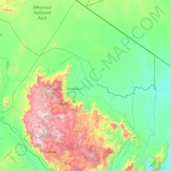
Nom : Carte topographique Lushoto, altitude, relief.
Lieu : Lushoto, Tanga Region, Northern Zone, Tanzania (-4.87986 38.11603 -4.11144 38.76080)
Altitude moyenne : 708 m
Altitude minimum : 174 m
Altitude maximum : 2 283 m
Autres cartes topographiques
Cliquez sur une carte pour visualiser sa topographie, son altitude et son relief.
Kwai
Kwai, Lushoto, Tanga Region, Northern Zone, Tanzania
Altitude moyenne : 1 746 m
Mkomazi
Mkomazi, Korogwe, Tanga Region, Northern Zone, Tanzania
Altitude moyenne : 482 m
Irente View Point
Tanzania > Tanga Region > Mombo
Irente View Point, T2, Mombo, Korogwe, Tanga Region, Northern Zone, Tanzania
Altitude moyenne : 1 175 m
Korogwe
Korogwe, Tanga Region, Northern Zone, Tanzania
Altitude moyenne : 747 m
Lushoto
Lushoto, Tanga Region, Northern Zone, Tanzania
Altitude moyenne : 1 492 m