
Carte topographique Gomati
Carte interactive
Cliquez sur la carte pour afficher l’altitude.
À propos de cette carte
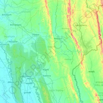
Nom : Carte topographique Gomati, altitude, relief.
Lieu : Gomati, Tripura, India (23.08611 91.37438 23.76944 91.84517)
Altitude moyenne : 67 m
Altitude minimum : 4 m
Altitude maximum : 385 m
Topographically, the Gomati district is marked by lush green and fertile Gomati valleys. The towering Debtamura hill range which straddles Udaipur and Amarpur subdivisions of the district with its exquisite sculptural works carved on panels of the hills.
Autres cartes topographiques
Cliquez sur une carte pour visualiser sa topographie, son altitude et son relief.
Haora River
Haora River, Agartala, West Tripura, Tripura, 799001, India
Altitude moyenne : 18 m
Kailashahar
India > Tripura > Gournagar > Kailashahar
Kailashahar, Gournagar, Unokoti, Tripura, 799277, India
Altitude moyenne : 33 m
South Tripura
India > Tripura > South Tripura
South Tripura, Gomati, Tripura, India
Altitude moyenne : 75 m