
Faire un don
Équipez-vous pour votre prochaine aventure :
En tant que Partenaire Amazon, ce site perçoit une commission sur les achats éligibles sans surcoût pour vous.
Carte topographique Killa
Cliquez sur la carte pour afficher l’altitude.
Faire un don
Équipez-vous pour votre prochaine aventure :
En tant que Partenaire Amazon, ce site perçoit une commission sur les achats éligibles sans surcoût pour vous.
À propos de cette carte
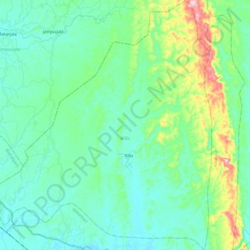
Nom : Carte topographique Killa, altitude, relief.
Lieu : Killa, Gomati, Tripura, 799114, India (23.54223 91.40989 23.73072 91.58611)
Altitude moyenne : 68 m
Altitude minimum : 20 m
Altitude maximum : 248 m
Faire un don
Équipez-vous pour votre prochaine aventure :
En tant que Partenaire Amazon, ce site perçoit une commission sur les achats éligibles sans surcoût pour vous.
Autres cartes topographiques
Cliquez sur une carte pour visualiser sa topographie, son altitude et son relief.
Faire un don
Équipez-vous pour votre prochaine aventure :
En tant que Partenaire Amazon, ce site perçoit une commission sur les achats éligibles sans surcoût pour vous.
Amarpur
India > Tripura > Amarpur Urban
Amarpur is located at 23°32′N 91°38′E / 23.53°N 91.64°E / 23.53; 91.64. It has an average elevation of 24 metres (78 feet) above sea level. The town is connected to Udaipur and Teliamura with metalled roads. It can be accessed from the capital city of Agartala via Udaipur town. The nearest…
Altitude moyenne : 54 m
Faire un don
Équipez-vous pour votre prochaine aventure :
En tant que Partenaire Amazon, ce site perçoit une commission sur les achats éligibles sans surcoût pour vous.
Faire un don
Équipez-vous pour votre prochaine aventure :
En tant que Partenaire Amazon, ce site perçoit une commission sur les achats éligibles sans surcoût pour vous.
Faire un don
Équipez-vous pour votre prochaine aventure :
En tant que Partenaire Amazon, ce site perçoit une commission sur les achats éligibles sans surcoût pour vous.