
Carte topographique Westland District
Carte interactive
Cliquez sur la carte pour afficher l’altitude.
À propos de cette carte
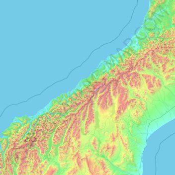
Nom : Carte topographique Westland District, altitude, relief.
Lieu : Westland District, West Coast, New Zealand (-44.49907 168.05287 -42.56006 171.88439)
Altitude moyenne : 437 m
Altitude minimum : -1 m
Altitude maximum : 3 457 m
Autres cartes topographiques
Cliquez sur une carte pour visualiser sa topographie, son altitude et son relief.
Punakaiki
New Zealand > West Coast > Buller District
Punakaiki, Buller District, West Coast, 7873, New Zealand
Altitude moyenne : 70 m
Douglas Pass
New Zealand > West Coast > Westland District
Douglas Pass, Westland District, West Coast, New Zealand
Altitude moyenne : 1 603 m
Lake Windermere
New Zealand > West Coast > Westland District
Lake Windermere, Westland District, West Coast, New Zealand
Altitude moyenne : 4 m
Katau Knob
New Zealand > West Coast > Westland District
Katau Knob, Westland District, West Coast, New Zealand
Altitude moyenne : 826 m
Pike Peak
New Zealand > West Coast > Buller District
Pike Peak, Buller District, West Coast, New Zealand
Altitude moyenne : 1 104 m
Snowden
New Zealand > West Coast > Westland District
Snowden, Westland District, West Coast, New Zealand
Altitude moyenne : 1 049 m
Mt Wilson
New Zealand > West Coast > Westland District
Mt Wilson, Westland District, West Coast, New Zealand
Altitude moyenne : 1 126 m
Ōkārito
New Zealand > West Coast > Westland District
Ōkārito, Westland District, West Coast, New Zealand
Altitude moyenne : 25 m
Mount Baldy
New Zealand > West Coast > Buller District
Mount Baldy, Buller District, West Coast, New Zealand
Altitude moyenne : 1 059 m
Whataroa River
New Zealand > West Coast > Westland District
Whataroa River, Westland District, West Coast, New Zealand
Altitude moyenne : 626 m