
Carte topographique Ōkārito
Carte interactive
Cliquez sur la carte pour afficher l’altitude.
À propos de cette carte
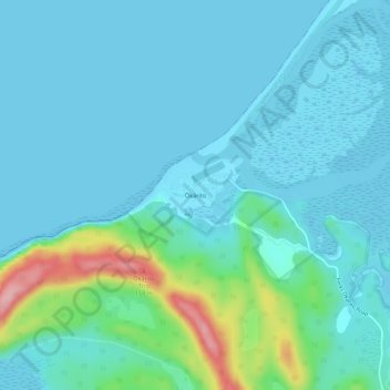
Nom : Carte topographique Ōkārito, altitude, relief.
Lieu : Ōkārito, Westland District, West Coast, New Zealand (-43.24355 170.14265 -43.20355 170.18265)
Altitude moyenne : 25 m
Altitude minimum : -4 m
Altitude maximum : 160 m
Autres cartes topographiques
Cliquez sur une carte pour visualiser sa topographie, son altitude et son relief.
Douglas Pass
New Zealand > West Coast > Westland District
Douglas Pass, Westland District, West Coast, New Zealand
Altitude moyenne : 1 603 m
Lake Windermere
New Zealand > West Coast > Westland District
Lake Windermere, Westland District, West Coast, New Zealand
Altitude moyenne : 4 m
Katau Knob
New Zealand > West Coast > Westland District
Katau Knob, Westland District, West Coast, New Zealand
Altitude moyenne : 826 m
Snowden
New Zealand > West Coast > Westland District
Snowden, Westland District, West Coast, New Zealand
Altitude moyenne : 1 049 m
Mt Wilson
New Zealand > West Coast > Westland District
Mt Wilson, Westland District, West Coast, New Zealand
Altitude moyenne : 1 126 m
Whataroa River
New Zealand > West Coast > Westland District
Whataroa River, Westland District, West Coast, New Zealand
Altitude moyenne : 626 m