
Faire un don
Équipez-vous pour votre prochaine aventure :
En tant que Partenaire Amazon, ce site perçoit une commission sur les achats éligibles sans surcoût pour vous.
Carte topographique Geislingen an der Steige
Cliquez sur la carte pour afficher l’altitude.
Faire un don
Équipez-vous pour votre prochaine aventure :
En tant que Partenaire Amazon, ce site perçoit une commission sur les achats éligibles sans surcoût pour vous.
Geislingen an der Steige
The importance of the Rorgensteig church for the religious life of the Geislingen community decreased since the elevation of the Geislingen Lady Chapel to a parish church (around 1393) and the construction of the present town church in the years 1424 to 1428. Rorgensteig with its mills had special significance as the first medieval "industrial center" of the town.
Faire un don
Équipez-vous pour votre prochaine aventure :
En tant que Partenaire Amazon, ce site perçoit une commission sur les achats éligibles sans surcoût pour vous.
À propos de cette carte
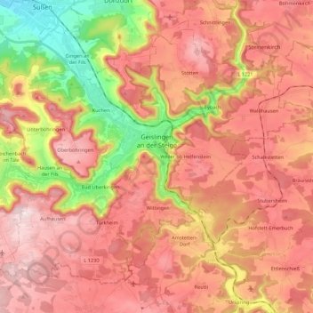
Nom : Carte topographique Geislingen an der Steige, altitude, relief.
Altitude moyenne : 612 m
Altitude minimum : 352 m
Altitude maximum : 786 m
Faire un don
Équipez-vous pour votre prochaine aventure :
En tant que Partenaire Amazon, ce site perçoit une commission sur les achats éligibles sans surcoût pour vous.
Autres cartes topographiques
Cliquez sur une carte pour visualiser sa topographie, son altitude et son relief.