
Faire un don
Équipez-vous pour votre prochaine aventure :
En tant que Partenaire Amazon, ce site perçoit une commission sur les achats éligibles sans surcoût pour vous.
Carte topographique Gosbach
Cliquez sur la carte pour afficher l’altitude.
Faire un don
Équipez-vous pour votre prochaine aventure :
En tant que Partenaire Amazon, ce site perçoit une commission sur les achats éligibles sans surcoût pour vous.
À propos de cette carte
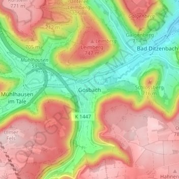
Nom : Carte topographique Gosbach, altitude, relief.
Altitude moyenne : 650 m
Altitude minimum : 497 m
Altitude maximum : 789 m
Faire un don
Équipez-vous pour votre prochaine aventure :
En tant que Partenaire Amazon, ce site perçoit une commission sur les achats éligibles sans surcoût pour vous.
Autres cartes topographiques
Cliquez sur une carte pour visualiser sa topographie, son altitude et son relief.
73312
Germany > Baden-Württemberg > Landkreis Göppingen > Geislingen an der Steige > Weiler ob Helfenstein
Altitude moyenne : 615 m
Ottenbach
Germany > Baden-Württemberg > Landkreis Göppingen
Cycling: Nationally known is Ottenbach for the organization and conduct of mass sports bike marathon "Alb-extreme". The itinerary leads annually on the last Sunday in June over a distance of 190, 210 and 260 km through the countryside of the Swabian Jura with many elevations.
Altitude moyenne : 449 m
Faire un don
Équipez-vous pour votre prochaine aventure :
En tant que Partenaire Amazon, ce site perçoit une commission sur les achats éligibles sans surcoût pour vous.
Geislingen an der Steige
Germany > Baden-Württemberg > Landkreis Göppingen
The importance of the Rorgensteig church for the religious life of the Geislingen community decreased since the elevation of the Geislingen Lady Chapel to a parish church (around 1393) and the construction of the present town church in the years 1424 to 1428. Rorgensteig with its mills had special significance…
Altitude moyenne : 612 m
Hohenstadt
Germany > Baden-Württemberg > Landkreis Göppingen
The municipality (Gemeinde) of Hohenstadt is situated in the district of Göppingen, of the German state of Baden-Württemberg. Hohenstadt lies at the southernmost tip of Göppingen's district, along its border with the Alb-Danube district. The municipal area is physically located in the Middle Kuppenalb [de].…
Altitude moyenne : 775 m
Eislingen/Fils
Germany > Baden-Württemberg > Landkreis Göppingen
The city (Stadt) of Eislingen is located in the north of the district of Göppingen, in the German state of Baden-Württemberg. Eislingen is physically located in the Fils river valley, at the mouth of the Krumm, in the central [de] and eastern foothills [de] of the Swabian Jura. Elevation above sea level in…
Altitude moyenne : 369 m
Faire un don
Équipez-vous pour votre prochaine aventure :
En tant que Partenaire Amazon, ce site perçoit une commission sur les achats éligibles sans surcoût pour vous.
Deggingen
Germany > Baden-Württemberg > Landkreis Göppingen > Deggingen
The municipality (Gemeinde) of Deggingen is found in the district of Göppingen, in Baden-Württemberg, one of the 16 States of the Federal Republic of Germany. Deggingen is physically located in the upper Fils river valley, in the Filsalb region of the Middle Kuppenalb . Elevation above sea level in the…
Altitude moyenne : 643 m
Donzdorf
Germany > Baden-Württemberg > Landkreis Göppingen
Donzdorf is located in the valley of the river Lauter, a tributary of the Fils river, 12 km east of Göppingen, on an elevation between 334 and 749 metres.
Altitude moyenne : 526 m
Geislingen an der Steige
Germany > Baden-Württemberg > Landkreis Göppingen
The importance of the Rorgensteig church for the religious life of the Geislingen community decreased since the elevation of the Geislingen Lady Chapel to a parish church (around 1393) and the construction of the present town church in the years 1424 to 1428. Rorgensteig with its mills had special significance…
Altitude moyenne : 612 m
Faire un don
Équipez-vous pour votre prochaine aventure :
En tant que Partenaire Amazon, ce site perçoit une commission sur les achats éligibles sans surcoût pour vous.