Géolocaliser

Carte topographique Athirappilly

Cliquez sur la carte pour afficher l’altitude.

À propos de cette carte

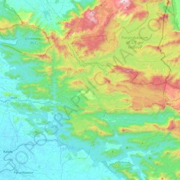
Nom : Carte topographique Athirappilly, altitude, relief.

Lieu : Athirappilly, Chalakkudy, Thrissur District, Kerala, India (10.25126 76.44857 10.38597 76.90142)

Altitude moyenne : 406 m

Altitude minimum : 0 m

Altitude maximum : 1 604 m

Autres cartes topographiques

Cliquez sur une carte pour visualiser sa topographie, son altitude et son relief.

Vallakkunnu

India > Kerala > Chalakkudy

Altitude moyenne : 10 m

Koratty

India > Kerala > Chalakkudy

Altitude moyenne : 14 m

Mala

India > Kerala > Chalakkudy

Altitude moyenne : 8 m

annamanada

India > Kerala > Chalakkudy

Altitude moyenne : 7 m

Valiyaparambu

India > Kerala > Chalakkudy

Altitude moyenne : 8 m

V.R Puram

India > Kerala > Chalakkudy

Altitude moyenne : 13 m

Nandipulam

India > Kerala > Chalakkudy

Altitude moyenne : 16 m

Pulikkanny

India > Kerala > Chalakkudy

Altitude moyenne : 36 m

Chalakudy

India > Kerala > Chalakkudy

Altitude moyenne : 15 m

Lower Sholayar Dam

India > Kerala > Chalakkudy

Altitude moyenne : 773 m

Chalakudy

India > Kerala > Chalakkudy

Altitude moyenne : 15 m

Chalakudy

India > Kerala > Chalakkudy

Altitude moyenne : 15 m

Équipez-vous pour votre prochaine aventure :

🌍Globe terrestre lumineux - Objet classique pour le bureau d'un amateur de géographie
📚Guide de survie en forêt - Connaissances essentielles pour les zones isolées
Couverture de survie thermique - Sac de bivouac d'urgence pour conserver la chaleur corporelle
🧰Outils multifonctions - Polyvalence et compacité
🎒Sacs à dos journée - Sacs compacts pour randonnées à la journée

En tant que Partenaire Amazon, ce site perçoit une commission sur les achats éligibles sans surcoût pour vous.