
Carte topographique Arequipa
Carte interactive
Cliquez sur la carte pour afficher l’altitude.
À propos de cette carte
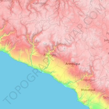
Nom : Carte topographique Arequipa, altitude, relief.
Lieu : Arequipa, Peru (-17.28501 -75.07199 -14.63274 -70.80408)
Altitude moyenne : 2 599 m
Altitude minimum : 0 m
Altitude maximum : 6 195 m
This department has a rough topography, which is characterised by heavy layers of volcanic lava covering large areas of its inter-Andean sector. It has deep canyons such as the ones formed by the Ocoña and Majes rivers. Plateaus range in height from medium, such as La Joya, and high-altitude ones such the Arrieros Pampa and those located in the zones of Chivay, Huambo and Pichucolla. Volcanic cones, such as Misti, Chachani, Ampato, Mismi, Solimana and Coropuna, emerge above the plateaus and attract snowfall. In contrast with these heights, there are deep canyons, including Majes, Colca, Sihuas and Ocoña, where important aspects of the ecological evolution of this zone can be clearly observed.
Autres cartes topographiques
Cliquez sur une carte pour visualiser sa topographie, son altitude et son relief.
Machu Picchu
Peru > Cusco > Machupicchu
Machu Picchu, Path to Inka Bridge, Machupicchu, Province of Urubamba, Cusco, 08680, Peru
Altitude moyenne : 2 227 m
Province of Moyobamba
Province of Moyobamba, San Martín, 22001, Peru
Altitude moyenne : 1 207 m
Rio Cañete
Rio Cañete, Huancachi, Tomas, Province of Yauyos, Lima, Peru
Altitude moyenne : 4 031 m
Cartagena
Peru > Lambayeque > Mórrope
Cartagena, Mórrope, Province of Lambayeque, Lambayeque, Peru
Altitude moyenne : 12 m
Callejon de Huaylas
Peru > Ica > Santiago > Mayuries
Callejon de Huaylas, Mayuries, Santiago, Province of Ica, Ica, Peru
Altitude moyenne : 388 m
Jequetepeque
Jequetepeque, Province of Pacasmayo, La Libertad, Peru
Altitude moyenne : 27 m
Constitutional Province of Callao
Constitutional Province of Callao, Peru
Altitude moyenne : 1 009 m
Santa Bárbara
Santa Bárbara, San Luis, Province of Cañete, Lima, Peru
Altitude moyenne : 5 m
Lecce Pata
Lecce Pata, Corani, Province of Carabaya, Puno, Peru
Altitude moyenne : 4 436 m
Santa Fe
Peru > Loreto > Emilio San Martín
Santa Fe, Emilio San Martín, Province of Requena, Loreto, Peru
Altitude moyenne : 103 m
Province of Cusco
Province of Cusco, Cusco, Peru, Province of Cusco
Altitude moyenne : 3 372 m
Province of Lima
Peru > Lima > Lima Metropolitan Area
Province of Lima, Lima Metropolitan Area, Lima, Peru
Altitude moyenne : 1 234 m
Province of Calca
Province of Calca, Cusco, Peru, Province of Calca
Altitude moyenne : 2 444 m
Province of Acomayo
Province of Acomayo, Cusco, Peru, Province of Acomayo
Altitude moyenne : 3 814 m
Province of Anta
Province of Anta, Cusco, Peru, Province of Anta
Altitude moyenne : 3 303 m
Province of La Convención
Province of La Convención, Cusco, Peru, Province of La Convención
Altitude moyenne : 1 597 m
Province of Paucartambo
Province of Paucartambo, Cusco, Peru, Province of Paucartambo
Altitude moyenne : 2 684 m
Province of Quispicanchis
Province of Quispicanchis, Cusco, Peru
Altitude moyenne : 2 920 m
Marcahuasi
Marcahuasi, Mollepata, Province of Anta, Cusco, Peru
Altitude moyenne : 2 438 m
City of Cuzco
City of Cuzco, Cusco, Distrito de Cusco, Province of Cusco, Cusco, 08001, Peru
Altitude moyenne : 3 453 m