
Carte topographique Oni, Georgia
Carte interactive
Cliquez sur la carte pour afficher l’altitude.
À propos de cette carte
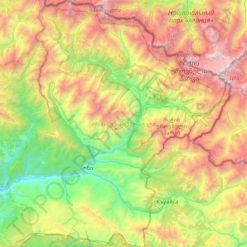
Nom : Carte topographique Oni, Georgia, altitude, relief.
Lieu : Oni, Georgia, Racha-Lechkhumi and Lower Svaneti, Georgia (42.43570 43.23767 42.89935 43.79587)
Altitude moyenne : 2 123 m
Altitude minimum : 621 m
Altitude maximum : 4 602 m
Autres cartes topographiques
Cliquez sur une carte pour visualiser sa topographie, son altitude et son relief.
Ambrolauri
Georgia > Racha-Lechkhumi and Lower Svaneti > Ambrolauri Municipality
Ambrolauri (Georgian: ამბროლაური) is a city in Georgia, located in the northwestern part of the country, on both banks of the Rioni river, at an elevation of 550 m above sea level. The city serves as the seat of the Racha-Lechkhumi and Kvemo Svaneti regional administration and of the…
Altitude moyenne : 624 m