
Carte topographique Peru
Carte interactive
Cliquez sur la carte pour afficher l’altitude.
À propos de cette carte
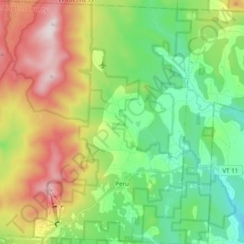
Nom : Carte topographique Peru, altitude, relief.
Lieu : Peru, Bennington County, Vermont, 05152, United States (43.20542 -72.97959 43.30416 -72.85991)
Altitude moyenne : 595 m
Altitude minimum : 341 m
Altitude maximum : 1 036 m
Peru is located in northeastern Bennington County, bordered by Rutland County to the north. The crest of the Green Mountains runs from north to the south through the western half of the town, traversed by the Long Trail/Appalachian Trail. 3,300-foot-high (1,000 m) Bromley Mountain and its ski area are in the southern part of the town, and 3,392-foot (1,034 m) Styles Peak and 3,428-foot (1,045 m) Peru Peak are to the north. The village or town center of Peru is in the southeastern part of town, at elevation 1,706 feet (520 m). Vermont Route 11 crosses the southeastern part of the town, through the town center and past Bromley Mountain Ski Area.
Autres cartes topographiques
Cliquez sur une carte pour visualiser sa topographie, son altitude et son relief.
Dorset
United States > Vermont > Bennington County
Dorset, Bennington County, Vermont, 05251, United States
Altitude moyenne : 343 m
Stratton Acres
United States > Vermont > Bennington County > Winhall
Stratton Acres, Winhall, Bennington County, Vermont, 05340, United States
Altitude moyenne : 512 m
Pownal Center
United States > Vermont > Bennington County > Pownal
Pownal Center, Pownal, Bennington County, Vermont, 05261, United States
Altitude moyenne : 311 m
Arlington
United States > Vermont > Bennington County
Arlington, Bennington County, Vermont, 05250, United States
Altitude moyenne : 385 m
South Shaftsbury
United States > Vermont > Bennington County > Shaftsbury
South Shaftsbury, Shaftsbury, Bennington County, Vermont, 05262, United States
Altitude moyenne : 258 m
Sunderland
United States > Vermont > Bennington County
Sunderland, Bennington County, Vermont, 05252, United States
Altitude moyenne : 500 m
North Pownal
United States > Vermont > Bennington County > Pownal
North Pownal, Pownal, Bennington County, Vermont, 05260, United States
Altitude moyenne : 254 m
North Bennington
United States > Vermont > Bennington County > Bennington
North Bennington, Bennington, Bennington County, Vermont, 05257, United States
Altitude moyenne : 196 m
Shaftsbury
United States > Vermont > Bennington County > Shaftsbury
Shaftsbury, Bennington County, Vermont, 05262, United States
Altitude moyenne : 355 m
Sandgate
United States > Vermont > Bennington County
Sandgate, Bennington County, Vermont, United States
Altitude moyenne : 480 m
Bennington
United States > Vermont > Bennington County
Bennington, Bennington County, Vermont, United States
Altitude moyenne : 313 m
Landgrove
United States > Vermont > Bennington County > Landgrove
Landgrove, Bennington County, Vermont, 05152, United States
Altitude moyenne : 491 m
Manchester Center
United States > Vermont > Bennington County > Manchester
Manchester Center, Manchester, Bennington County, Vermont, 05255, United States
Altitude moyenne : 384 m
Bromley Mountain
United States > Vermont > Bennington County > Peru
Bromley Mountain, Peru, Bennington County, Vermont, 05152, United States
Altitude moyenne : 777 m
Green Mountain National Forest
United States > Vermont > Bennington County
Green Mountain National Forest, Bennington County, Vermont, United States
Altitude moyenne : 348 m
Gale Meadows Pond
United States > Vermont > Bennington County > Winhall > French Hollow
Gale Meadows Pond, French Hollow, Winhall, Bennington County, Vermont, United States
Altitude moyenne : 437 m
Manchester
United States > Vermont > Bennington County
Manchester, Bennington County, Vermont, United States
Altitude moyenne : 453 m
Dorset Quarry
United States > Vermont > Bennington County > Dorset
Dorset Quarry, Dorset, Bennington County, Vermont, United States
Altitude moyenne : 346 m
Arlington
United States > Vermont > Bennington County > Arlington
Arlington, Bennington County, Vermont, United States
Altitude moyenne : 282 m
Winhall
United States > Vermont > Bennington County
Winhall, Bennington County, Vermont, 05340, United States
Altitude moyenne : 578 m
Shaftsbury
United States > Vermont > Bennington County
Shaftsbury, Bennington County, Vermont, 05262, United States
Altitude moyenne : 395 m
Pownal
United States > Vermont > Bennington County
Pownal, Bennington County, Vermont, United States
Altitude moyenne : 369 m
Woodford
United States > Vermont > Bennington County
Woodford, Bennington County, Vermont, United States
Altitude moyenne : 670 m
Bondville
United States > Vermont > Bennington County > Winhall
Bondville, Winhall, Bennington County, Vermont, 05340, United States
Altitude moyenne : 486 m
Searsburg
United States > Vermont > Bennington County
Searsburg, Bennington County, Vermont, United States
Altitude moyenne : 675 m
Glastenbury
United States > Vermont > Bennington County
Glastenbury, Bennington County, Vermont, United States
Altitude moyenne : 740 m
Rupert
United States > Vermont > Bennington County
Rupert, Bennington County, Vermont, United States
Altitude moyenne : 360 m
Readsboro
United States > Vermont > Bennington County
Readsboro, Bennington County, Vermont, 05350, United States
Altitude moyenne : 596 m
Landgrove
United States > Vermont > Bennington County
Landgrove, Bennington County, Vermont, United States
Altitude moyenne : 479 m
Old Bennington
United States > Vermont > Bennington County > Bennington
Old Bennington, Bennington, Bennington County, Vermont, United States
Altitude moyenne : 245 m