
Carte topographique Glastenbury
Carte interactive
Cliquez sur la carte pour afficher l’altitude.
À propos de cette carte
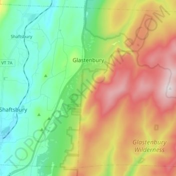
Nom : Carte topographique Glastenbury, altitude, relief.
Lieu : Glastenbury, Bennington County, Vermont, United States (42.93025 -73.14600 43.02582 -73.00323)
Altitude moyenne : 740 m
Altitude minimum : 292 m
Altitude maximum : 1 142 m
Despite the many hardships that greeted Glastenbury settlers, newcomers continued to arrive in small numbers, and the population grew slowly to 76 in 1810. But the years following 1810 were hard ones for all of Vermont, and by 1840 there were only 53 left in Glastenbury. After the Civil War, Glastenbury finally began to experience more rapid growth. Business interests in nearby Bennington were eager to take advantage of the vast timber resources there, and by 1872 had finally begun construction on a railroad (trolley) which ran up the mountain. The line ran along Bolles Brook and terminated at the place where the brook forked. It was an improbable achievement, with some parts of the line climbing as much as 250 feet (76 m) in altitude per mile. Remains of the old trolley tracks can still be seen today.
Autres cartes topographiques
Cliquez sur une carte pour visualiser sa topographie, son altitude et son relief.
Dorset
United States > Vermont > Bennington County
Dorset, Bennington County, Vermont, 05251, United States
Altitude moyenne : 343 m
Stratton Acres
United States > Vermont > Bennington County > Winhall
Stratton Acres, Winhall, Bennington County, Vermont, 05340, United States
Altitude moyenne : 512 m
Pownal Center
United States > Vermont > Bennington County > Pownal
Pownal Center, Pownal, Bennington County, Vermont, 05261, United States
Altitude moyenne : 311 m
Arlington
United States > Vermont > Bennington County
Arlington, Bennington County, Vermont, 05250, United States
Altitude moyenne : 385 m
Peru
United States > Vermont > Bennington County
Peru, Bennington County, Vermont, 05152, United States
Altitude moyenne : 595 m
South Shaftsbury
United States > Vermont > Bennington County > Shaftsbury
South Shaftsbury, Shaftsbury, Bennington County, Vermont, 05262, United States
Altitude moyenne : 258 m
Sunderland
United States > Vermont > Bennington County
Sunderland, Bennington County, Vermont, 05252, United States
Altitude moyenne : 500 m
North Pownal
United States > Vermont > Bennington County > Pownal
North Pownal, Pownal, Bennington County, Vermont, 05260, United States
Altitude moyenne : 254 m
North Bennington
United States > Vermont > Bennington County > Bennington
North Bennington, Bennington, Bennington County, Vermont, 05257, United States
Altitude moyenne : 196 m
Shaftsbury
United States > Vermont > Bennington County > Shaftsbury
Shaftsbury, Bennington County, Vermont, 05262, United States
Altitude moyenne : 355 m
Sandgate
United States > Vermont > Bennington County
Sandgate, Bennington County, Vermont, United States
Altitude moyenne : 480 m
Bennington
United States > Vermont > Bennington County
Bennington, Bennington County, Vermont, United States
Altitude moyenne : 313 m
Landgrove
United States > Vermont > Bennington County > Landgrove
Landgrove, Bennington County, Vermont, 05152, United States
Altitude moyenne : 491 m
Manchester Center
United States > Vermont > Bennington County > Manchester
Manchester Center, Manchester, Bennington County, Vermont, 05255, United States
Altitude moyenne : 384 m
Bromley Mountain
United States > Vermont > Bennington County > Peru
Bromley Mountain, Peru, Bennington County, Vermont, 05152, United States
Altitude moyenne : 777 m
Green Mountain National Forest
United States > Vermont > Bennington County
Green Mountain National Forest, Bennington County, Vermont, United States
Altitude moyenne : 348 m
Gale Meadows Pond
United States > Vermont > Bennington County > Winhall > French Hollow
Gale Meadows Pond, French Hollow, Winhall, Bennington County, Vermont, United States
Altitude moyenne : 437 m
Manchester
United States > Vermont > Bennington County
Manchester, Bennington County, Vermont, United States
Altitude moyenne : 453 m
Dorset Quarry
United States > Vermont > Bennington County > Dorset
Dorset Quarry, Dorset, Bennington County, Vermont, United States
Altitude moyenne : 346 m
Arlington
United States > Vermont > Bennington County > Arlington
Arlington, Bennington County, Vermont, United States
Altitude moyenne : 282 m
Winhall
United States > Vermont > Bennington County
Winhall, Bennington County, Vermont, 05340, United States
Altitude moyenne : 578 m
Shaftsbury
United States > Vermont > Bennington County
Shaftsbury, Bennington County, Vermont, 05262, United States
Altitude moyenne : 395 m
Pownal
United States > Vermont > Bennington County
Pownal, Bennington County, Vermont, United States
Altitude moyenne : 369 m
Woodford
United States > Vermont > Bennington County
Woodford, Bennington County, Vermont, United States
Altitude moyenne : 670 m
Bondville
United States > Vermont > Bennington County > Winhall
Bondville, Winhall, Bennington County, Vermont, 05340, United States
Altitude moyenne : 486 m
Searsburg
United States > Vermont > Bennington County
Searsburg, Bennington County, Vermont, United States
Altitude moyenne : 675 m
Rupert
United States > Vermont > Bennington County
Rupert, Bennington County, Vermont, United States
Altitude moyenne : 360 m
Readsboro
United States > Vermont > Bennington County
Readsboro, Bennington County, Vermont, 05350, United States
Altitude moyenne : 596 m
Landgrove
United States > Vermont > Bennington County
Landgrove, Bennington County, Vermont, United States
Altitude moyenne : 479 m
Old Bennington
United States > Vermont > Bennington County > Bennington
Old Bennington, Bennington, Bennington County, Vermont, United States
Altitude moyenne : 245 m