
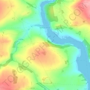
Carte topographique Kilmacsimon
Carte interactive
Cliquez sur la carte pour afficher l’altitude.
À propos de cette carte
Nom : Carte topographique Kilmacsimon, altitude, relief.
Altitude moyenne : 50 m
Altitude minimum : 0 m
Altitude maximum : 114 m
Autres cartes topographiques
Cliquez sur une carte pour visualiser sa topographie, son altitude et son relief.
Cork
Ireland > County Cork > Cork
Cork, County Cork, Munster, T12 T997, Ireland
Altitude moyenne : 94 m
Drimoleague
Drimoleague, West Cork, County Cork, Munster, P47 D368, Ireland
Altitude moyenne : 89 m
Roches Point
Roches Point, Corkbeg ED, The Municipal District of East Cork, County Cork, Munster, P25 A062, Ireland
Altitude moyenne : 8 m
Shronacarton
Shronacarton, Dromdaleague South, West Cork, County Cork, Munster, Ireland
Altitude moyenne : 116 m
Knockraha
Knockraha, Municipal District of Cobh, County Cork, Munster, Ireland
Altitude moyenne : 114 m
Killeena
Killeena, Knockraha, Municipal District of Cobh, County Cork, Munster, Ireland
Altitude moyenne : 111 m
Belgooly
Belgooly, The Municipal District of Bandon-Kinsale, County Cork, Munster, Ireland
Altitude moyenne : 42 m
Mitchelstown
Mitchelstown, The Municipal District of Fermoy, County Cork, Munster, Ireland
Altitude moyenne : 105 m
Corbally
Corbally, Kildinan, The Municipal District of Fermoy, County Cork, Munster, Ireland
Altitude moyenne : 113 m
Ballineen
Ballineen, West Cork, County Cork, Munster, P47 R623, Ireland
Altitude moyenne : 76 m
Great Island
Great Island, Municipal District of Cobh, County Cork, Munster, Ireland
Altitude moyenne : 20 m
Knockeen
Knockeen, Coulagh ED ED, West Cork, County Cork, Munster, P75 PE80, Ireland
Altitude moyenne : 145 m
Carriganimmy
Carriganimmy, Municipal District of Macroom, County Cork, Munster, P12 DW92, Ireland
Altitude moyenne : 242 m
Arderrow
Ireland > County Cork > Cork
Arderrow, Rathcooney, Cork, County Cork, Munster, T23 P270, Ireland
Altitude moyenne : 95 m
Knockeennagroagh
Knockeennagroagh, Gortroe, The Municipal District of Fermoy, County Cork, Munster, Ireland
Altitude moyenne : 182 m
Castlepook
Castlepook, Ballinree Bridge, Streamhill, The Municipal District of Fermoy, County Cork, Munster, Ireland
Altitude moyenne : 98 m
Douglas
Ireland > County Cork > Cork
Douglas, Cork, County Cork, Munster, Ireland
Altitude moyenne : 34 m
Maryborough
Ireland > County Cork > Cork
Maryborough, Douglas, Cork, County Cork, Munster, Ireland
Altitude moyenne : 51 m
Drombeg
Drombeg, Kilfaughnabeg, West Cork, County Cork, Munster, Ireland
Altitude moyenne : 77 m
Lismire
Lismire, Barleyhill ED, The Municipal District of Kanturk-Mallow, County Cork, Munster, Ireland
Altitude moyenne : 192 m
Bunlick
Bunlick, Skibbereen Rural, West Cork, County Cork, Munster, Ireland
Altitude moyenne : 32 m
Lissardagh
Lissardagh, Warrenscourt, Municipal District of Macroom, County Cork, Munster, Ireland
Altitude moyenne : 109 m
Shanagarry
Shanagarry, The Municipal District of East Cork, County Cork, Munster, P25 HX82, Ireland
Altitude moyenne : 14 m
Ardgroom
Ardgroom, West Cork, County Cork, Munster, Ireland
Altitude moyenne : 56 m
Millstreet
Millstreet, Municipal District of Macroom, County Cork, Munster, Ireland
Altitude moyenne : 140 m
Meelin
Meelin, The Municipal District of Kanturk-Mallow, County Cork, Munster, Ireland
Altitude moyenne : 246 m
Bandon
Bandon, The Municipal District of Bandon-Kinsale, County Cork, Munster, Ireland
Altitude moyenne : 59 m
Ardnahinch
Ardnahinch, Ballycottin ED, The Municipal District of East Cork, County Cork, Munster, Ireland
Altitude moyenne : 5 m
Curraglass
Curraglass, Templemary, The Municipal District of Kanturk-Mallow, County Cork, Munster, Ireland
Altitude moyenne : 135 m
Kilgobbin
Kilgobbin, Ballinadee ED, The Municipal District of Bandon-Kinsale, County Cork, Munster, Ireland
Altitude moyenne : 85 m
Ballincollig
Ireland > County Cork > Cork
Ballincollig, Cork, County Cork, Munster, P31 TW88, Ireland
Altitude moyenne : 62 m
Inchigeelagh
Inchigeelagh, Municipal District of Macroom, County Cork, Munster, P12 W864, Ireland
Altitude moyenne : 135 m
Knockawaddra
Knockawaddra, Ballingurteen ED, West Cork, County Cork, Munster, Ireland
Altitude moyenne : 154 m
Killeagh
Killeagh, The Municipal District of East Cork, County Cork, Munster, P36 KN61, Ireland
Altitude moyenne : 32 m
Gortroe
Gortroe, The Municipal District of Fermoy, County Cork, Munster, P61 TD96, Ireland
Altitude moyenne : 120 m
Coolmore Cross
Coolmore Cross, Carrigaline ED, Municipal District of Carrigaline, County Cork, Munster, P43 DA03, Ireland
Altitude moyenne : 21 m
Water-rock
Water-rock, Carrigtohill ED, Municipal District of Cobh, County Cork, Munster, Ireland
Altitude moyenne : 22 m
Lyre
Lyre, Tincoora, The Municipal District of Kanturk-Mallow, County Cork, Munster, Ireland
Altitude moyenne : 214 m
Dundareirke
Dundareirke, Kilnamartery, Municipal District of Macroom, County Cork, Munster, Ireland
Altitude moyenne : 116 m
Castlemartyr
Castlemartyr, The Municipal District of East Cork, County Cork, Munster, Ireland
Altitude moyenne : 14 m
Berrings
Berrings, Dripsey, Municipal District of Macroom, County Cork, Munster, Ireland
Altitude moyenne : 113 m
Ballincollig Regional Park
Ireland > County Cork > Cork
Ballincollig Regional Park, West Village, Carrigrohane Beg ED, Cork, County Cork, Munster, Ireland
Altitude moyenne : 55 m
Castletownroche
Castletownroche, The Municipal District of Fermoy, County Cork, Munster, P51 K064, Ireland
Altitude moyenne : 67 m
Ballymore
Ballymore, Cobh Rural ED, Municipal District of Cobh, County Cork, Munster, Ireland
Altitude moyenne : 40 m
Moneyreague
Moneyreague, Coolmountain ED, West Cork, County Cork, Munster, Ireland
Altitude moyenne : 122 m
Macroom
Macroom, Municipal District of Macroom, County Cork, Munster, Ireland
Altitude moyenne : 110 m