
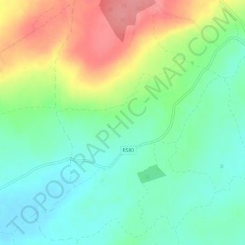
Carte topographique Curraglass
Carte interactive
Cliquez sur la carte pour afficher l’altitude.
À propos de cette carte
Nom : Carte topographique Curraglass, altitude, relief.
Altitude moyenne : 135 m
Altitude minimum : 101 m
Altitude maximum : 192 m
Autres cartes topographiques
Cliquez sur une carte pour visualiser sa topographie, son altitude et son relief.
Cork
Ireland > County Cork > Cork
Cork, County Cork, Munster, T12 T997, Ireland
Altitude moyenne : 94 m
Shanagarry
Shanagarry, The Municipal District of East Cork, County Cork, Munster, P25 HX82, Ireland
Altitude moyenne : 14 m
Ardnahinch
Ardnahinch, Ballycottin ED, The Municipal District of East Cork, County Cork, Munster, Ireland
Altitude moyenne : 5 m
Bandon
Bandon, The Municipal District of Bandon-Kinsale, County Cork, Munster, Ireland
Altitude moyenne : 59 m
Meelin
Meelin, The Municipal District of Kanturk-Mallow, County Cork, Munster, Ireland
Altitude moyenne : 246 m
Kilgobbin
Kilgobbin, Ballinadee ED, The Municipal District of Bandon-Kinsale, County Cork, Munster, Ireland
Altitude moyenne : 85 m
Ballincollig
Ireland > County Cork > Cork
Ballincollig, Cork, County Cork, Munster, P31 TW88, Ireland
Altitude moyenne : 62 m
Inchigeelagh
Inchigeelagh, Municipal District of Macroom, County Cork, Munster, P12 W864, Ireland
Altitude moyenne : 135 m
Knockawaddra
Knockawaddra, Ballingurteen ED, West Cork, County Cork, Munster, Ireland
Altitude moyenne : 154 m
Coolmore Cross
Coolmore Cross, Carrigaline ED, Municipal District of Carrigaline, County Cork, Munster, P43 DA03, Ireland
Altitude moyenne : 21 m
Killeagh
Killeagh, The Municipal District of East Cork, County Cork, Munster, P36 KN61, Ireland
Altitude moyenne : 32 m
Gortroe
Gortroe, The Municipal District of Fermoy, County Cork, Munster, P61 TD96, Ireland
Altitude moyenne : 120 m
Lyre
Lyre, Tincoora, The Municipal District of Kanturk-Mallow, County Cork, Munster, Ireland
Altitude moyenne : 214 m
Water-rock
Water-rock, Carrigtohill ED, Municipal District of Cobh, County Cork, Munster, Ireland
Altitude moyenne : 22 m
Castletownroche
Castletownroche, The Municipal District of Fermoy, County Cork, Munster, P51 K064, Ireland
Altitude moyenne : 67 m
Dundareirke
Dundareirke, Kilnamartery, Municipal District of Macroom, County Cork, Munster, Ireland
Altitude moyenne : 116 m
Castlemartyr
Castlemartyr, The Municipal District of East Cork, County Cork, Munster, Ireland
Altitude moyenne : 14 m
Ballincollig Regional Park
Ireland > County Cork > Cork
Ballincollig Regional Park, West Village, Carrigrohane Beg ED, Cork, County Cork, Munster, Ireland
Altitude moyenne : 55 m
Berrings
Berrings, Dripsey, Municipal District of Macroom, County Cork, Munster, Ireland
Altitude moyenne : 113 m
Moneyreague
Moneyreague, Coolmountain ED, West Cork, County Cork, Munster, Ireland
Altitude moyenne : 122 m
Macroom
Macroom, Municipal District of Macroom, County Cork, Munster, Ireland
Altitude moyenne : 110 m
Waterfall
Waterfall, Inishkenny, Municipal District of Carrigaline, County Cork, Munster, T12 CYF2, Ireland
Altitude moyenne : 96 m
Ballymore
Ballymore, Cobh Rural ED, Municipal District of Cobh, County Cork, Munster, Ireland
Altitude moyenne : 40 m
Aghabullogue
Aghabullogue, Municipal District of Macroom, County Cork, Munster, P12 DY92, Ireland
Altitude moyenne : 133 m
Liscahane Beg
Liscahane Beg, Kinsale Rural, The Municipal District of Bandon-Kinsale, County Cork, Munster, Ireland
Altitude moyenne : 47 m
Kilmurry
Kilmurry, Municipal District of Macroom, County Cork, Munster, P14 R940, Ireland
Altitude moyenne : 122 m
Mallow
Mallow, The Municipal District of Kanturk-Mallow, County Cork, Munster, Ireland
Altitude moyenne : 77 m
Baltimore
Baltimore, West Cork, County Cork, Munster, P81 F623, Ireland
Altitude moyenne : 23 m
Kilmacsimon
Kilmacsimon, Knockroe, The Municipal District of Bandon-Kinsale, County Cork, Munster, Ireland
Altitude moyenne : 50 m
Timoleague
Timoleague, The Municipal District of Bandon-Kinsale, County Cork, Munster, P72 DX23, Ireland
Altitude moyenne : 48 m
Dromsarane
Dromsarane, Castlemartyr ED, The Municipal District of East Cork, County Cork, Munster, Ireland
Altitude moyenne : 54 m
Glounthaune
Glounthaune, Municipal District of Cobh, County Cork, Munster, T45 V201, Ireland
Altitude moyenne : 52 m
Tawnies Lower
Tawnies Lower, Clonakilty Urban ED, West Cork, County Cork, Munster, Ireland
Altitude moyenne : 46 m
Ladysbridge
Ladysbridge, Ightermurragh, The Municipal District of East Cork, County Cork, Munster, P25 X820, Ireland
Altitude moyenne : 30 m
Ringcurran
Ringcurran, The Municipal District of Bandon-Kinsale, County Cork, Munster, Ireland
Altitude moyenne : 60 m
Ardamadane
Ireland > County Cork > Cork
Ardamadane, Blarney ED, Cork, County Cork, Munster, Ireland
Altitude moyenne : 92 m
Doneraile
Doneraile, The Municipal District of Fermoy, County Cork, Munster, Ireland
Altitude moyenne : 85 m
Kilmaclenine
Kilmaclenine, The Municipal District of Kanturk-Mallow, County Cork, Munster, Ireland
Altitude moyenne : 109 m
Dunbulloge
Dunbulloge, Killeagh, Municipal District of Cobh, County Cork, Munster, Ireland
Altitude moyenne : 117 m
Ringrone
Ringrone, Kinsale Rural, The Municipal District of Bandon-Kinsale, County Cork, Munster, Ireland
Altitude moyenne : 41 m
Monkstown
Ireland > County Cork > Municipal District of Carrigaline
Monkstown, Municipal District of Carrigaline, County Cork, Munster, T12 KT5N, Ireland
Altitude moyenne : 44 m
Aghada
Aghada, Corkbeg ED, The Municipal District of East Cork, County Cork, Munster, P25 HX04, Ireland
Altitude moyenne : 25 m
Halfway
Halfway, Dunderrow, Municipal District of Carrigaline, County Cork, Munster, T12 KT99, Ireland
Altitude moyenne : 96 m
Cloghmacow
Cloghmacow, Warrenscourt, Municipal District of Macroom, County Cork, Munster, Ireland
Altitude moyenne : 118 m
Roughgrove East
Roughgrove East, Kilbrogan, The Municipal District of Bandon-Kinsale, County Cork, Munster, Ireland
Altitude moyenne : 105 m
Banteer
Banteer, The Municipal District of Kanturk-Mallow, County Cork, Munster, Ireland
Altitude moyenne : 85 m