
Carte topographique Kendujhar
Carte interactive
Cliquez sur la carte pour afficher l’altitude.
À propos de cette carte
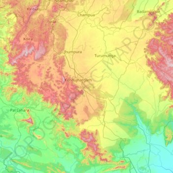
Nom : Carte topographique Kendujhar, altitude, relief.
Lieu : Kendujhar, Odisha, India (21.01581 85.18423 22.16259 86.37039)
Altitude moyenne : 371 m
Altitude minimum : 20 m
Altitude maximum : 1 150 m
The highlands consist of clusters of rugged crags and the mountaintops appear to be sharply ridged or peaked, however they have extensive tablelands on their summits. In some areas, isolated hills rise abruptly from the plains, but most areas have a general elevation of over 600m. The highlands form the watershed for a number of rivers, including the Baitarani River.
Autres cartes topographiques
Cliquez sur une carte pour visualiser sa topographie, son altitude et son relief.
Behera
India > Odisha > Bargarh Sadar > Behera
Behera, Bargarh Sadar, Bargarh, Odisha, India
Altitude moyenne : 172 m