
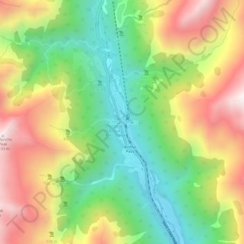
Carte topographique Arthur's Pass
Carte interactive
Cliquez sur la carte pour afficher l’altitude.
À propos de cette carte
Nom : Carte topographique Arthur's Pass, altitude, relief.
Altitude moyenne : 1 204 m
Altitude minimum : 706 m
Altitude maximum : 1 834 m
Arthur's Pass township is about five kilometres (3.1 mi) south of the mountain pass with the same name. At an elevation of 740 metres (2,430 ft) above sea level, the settlement is surrounded by beech forest. The Bealey River runs through the township. The town is located 153 kilometres (95 mi) from Christchurch, a two-hour drive on State Highway 73.
Autres cartes topographiques
Cliquez sur une carte pour visualiser sa topographie, son altitude et son relief.
Puketeraki
New Zealand > Canterbury > Selwyn District
Puketeraki, Selwyn District, Canterbury, New Zealand
Altitude moyenne : 1 369 m
Hydra Island
New Zealand > Canterbury > Selwyn District
Hydra Island, Selwyn District, Canterbury, New Zealand
Altitude moyenne : 474 m
Selwyn
New Zealand > Canterbury > Selwyn District
Selwyn, Selwyn District, Canterbury, 7682, New Zealand
Altitude moyenne : 70 m
Greendale
New Zealand > Canterbury > Selwyn District
Greendale, Selwyn District, Canterbury, 7671, New Zealand
Altitude moyenne : 132 m
Rolleston
New Zealand > Canterbury > Selwyn District
Rolleston, Selwyn District, Canterbury, 7643, New Zealand
Altitude moyenne : 54 m
Lincoln
New Zealand > Canterbury > Selwyn District
Lincoln, Selwyn District, Canterbury, 7608, New Zealand
Altitude moyenne : 15 m
Darfield
New Zealand > Canterbury > Selwyn District
Darfield, Selwyn District, Canterbury, 7510, New Zealand
Altitude moyenne : 202 m
Mount Cotton
New Zealand > Canterbury > Selwyn District
Mount Cotton, Selwyn District, Canterbury, New Zealand
Altitude moyenne : 1 031 m