
Carte topographique Hydra Island
Carte interactive
Cliquez sur la carte pour afficher l’altitude.
À propos de cette carte
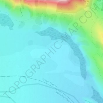
Nom : Carte topographique Hydra Island, altitude, relief.
Lieu : Hydra Island, Selwyn District, Canterbury, New Zealand (-43.27856 171.34181 -43.25856 171.36181)
Altitude moyenne : 474 m
Altitude minimum : 441 m
Altitude maximum : 633 m
Autres cartes topographiques
Cliquez sur une carte pour visualiser sa topographie, son altitude et son relief.
Puketeraki
New Zealand > Canterbury > Selwyn District
Puketeraki, Selwyn District, Canterbury, New Zealand
Altitude moyenne : 1 369 m
Selwyn
New Zealand > Canterbury > Selwyn District
Selwyn, Selwyn District, Canterbury, 7682, New Zealand
Altitude moyenne : 70 m
Rolleston
New Zealand > Canterbury > Selwyn District
Rolleston, Selwyn District, Canterbury, 7643, New Zealand
Altitude moyenne : 54 m
Greendale
New Zealand > Canterbury > Selwyn District
Greendale, Selwyn District, Canterbury, 7671, New Zealand
Altitude moyenne : 132 m
Lincoln
New Zealand > Canterbury > Selwyn District
Lincoln, Selwyn District, Canterbury, 7608, New Zealand
Altitude moyenne : 15 m
Darfield
New Zealand > Canterbury > Selwyn District
Darfield, Selwyn District, Canterbury, 7510, New Zealand
Altitude moyenne : 202 m
Arthur's Pass
New Zealand > Canterbury > Selwyn District
Arthur's Pass, Selwyn District, Canterbury, 7875, New Zealand
Altitude moyenne : 1 204 m
Mount Cotton
New Zealand > Canterbury > Selwyn District
Mount Cotton, Selwyn District, Canterbury, New Zealand
Altitude moyenne : 1 031 m