
Carte topographique Halti
Carte interactive
Cliquez sur la carte pour afficher l’altitude.
À propos de cette carte
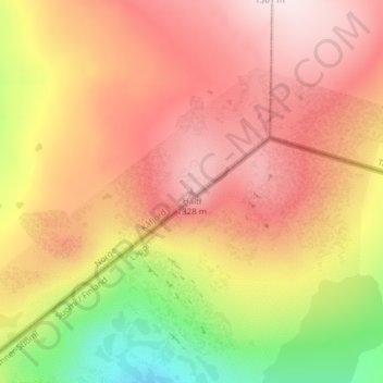
Nom : Carte topographique Halti, altitude, relief.
Lieu : Halti, Kåfjord, Troms og Finnmark, Norway (69.30801 21.26327 69.30811 21.26337)
Altitude moyenne : 1 192 m
Altitude minimum : 950 m
Altitude maximum : 1 358 m
Halti (Finnish: Halti, rarely Haltiatunturi, Northern Sami: Háldičohkka, Swedish: Halde fjäll) is a fell at the border between Norway and Finland. The peak (elevation 1,365 m (4,478 ft)) of the fell, called Ráisduattarháldi, is in Norway, on the border between the municipalities of Nordreisa and Gáivuotna–Kåfjord, about 1 kilometre (0.62 mi) north of the border with Finland. The highest point of the fell on the Finnish side is at 1,324 m (4,344 ft) above sea level, and thus the highest point in the country. The Finnish side of Halti belongs to the municipality of Enontekiö in the province of Lapland.
Autres cartes topographiques
Cliquez sur une carte pour visualiser sa topographie, son altitude et son relief.
Finnmark
Finnmark, Bamble, Vestfold og Telemark, 3967, Norway
Altitude moyenne : 38 m
Gaustatoppen
Gaustatoppen, Tinn, Vestfold og Telemark, 3660, Norway
Altitude moyenne : 1 360 m
Gihtsejiegŋa
Gihtsejiegŋa, Nordkalottruta, Tysfjord, Nordland, Norway
Altitude moyenne : 1 096 m
Folgefonna
Folgefonna, Gardshammar, Kvinnherad, Hordaland, Norway
Altitude moyenne : 709 m