
Carte topographique Barents Island
Carte interactive
Cliquez sur la carte pour afficher l’altitude.
À propos de cette carte
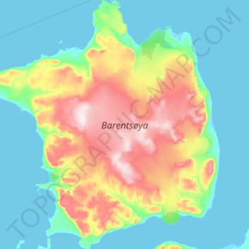
Nom : Carte topographique Barents Island, altitude, relief.
Lieu : Barents Island, Svalbard, Norway (78.20174 20.14429 78.63831 22.20408)
Altitude moyenne : 131 m
Altitude minimum : -3 m
Altitude maximum : 655 m
Autres cartes topographiques
Cliquez sur une carte pour visualiser sa topographie, son altitude et son relief.
Finnmark
Finnmark, Bamble, Vestfold og Telemark, 3967, Norway
Altitude moyenne : 38 m
Gaustatoppen
Gaustatoppen, Tinn, Vestfold og Telemark, 3660, Norway
Altitude moyenne : 1 360 m
Gihtsejiegŋa
Gihtsejiegŋa, Nordkalottruta, Tysfjord, Nordland, Norway
Altitude moyenne : 1 096 m
Folgefonna
Folgefonna, Gardshammar, Kvinnherad, Hordaland, Norway
Altitude moyenne : 709 m