
Faire un don
Équipez-vous pour votre prochaine aventure :
En tant que Partenaire Amazon, ce site perçoit une commission sur les achats éligibles sans surcoût pour vous.
Carte topographique Schildthurn
Cliquez sur la carte pour afficher l’altitude.
Faire un don
Équipez-vous pour votre prochaine aventure :
En tant que Partenaire Amazon, ce site perçoit une commission sur les achats éligibles sans surcoût pour vous.
À propos de cette carte
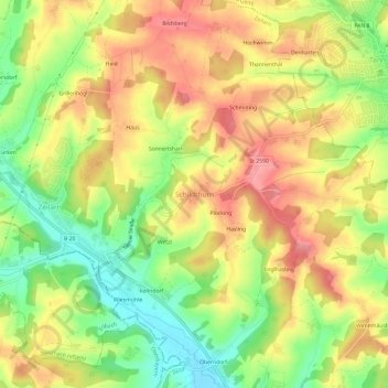
Nom : Carte topographique Schildthurn, altitude, relief.
Altitude moyenne : 460 m
Altitude minimum : 404 m
Altitude maximum : 509 m
Faire un don
Équipez-vous pour votre prochaine aventure :
En tant que Partenaire Amazon, ce site perçoit une commission sur les achats éligibles sans surcoût pour vous.
Autres cartes topographiques
Cliquez sur une carte pour visualiser sa topographie, son altitude et son relief.
Pfarrkirchen
Deutschland > Bayern > Landkreis Rottal-Inn
Die Stadt liegt am Fluss Rott im Rottal. Der Hauptort zieht sich nördlich der Rott, über die Höhen des Galgenberges und des Gartlberges bis zum Reichenberg als homogene Bebauung.
Altitude moyenne : 429 m
Faire un don
Équipez-vous pour votre prochaine aventure :
En tant que Partenaire Amazon, ce site perçoit une commission sur les achats éligibles sans surcoût pour vous.
Faire un don
Équipez-vous pour votre prochaine aventure :
En tant que Partenaire Amazon, ce site perçoit une commission sur les achats éligibles sans surcoût pour vous.
Rott
Deutschland > Bayern > Landkreis Rottal-Inn > Bayerbach > Bayerbach an der Rott > Voitl in der Au
Altitude moyenne : 358 m
Faire un don
Équipez-vous pour votre prochaine aventure :
En tant que Partenaire Amazon, ce site perçoit une commission sur les achats éligibles sans surcoût pour vous.
84359
Deutschland > Bayern > Landkreis Rottal-Inn > Simbach > Kirchberg am Inn > Wiesing
Altitude moyenne : 433 m
Faire un don
Équipez-vous pour votre prochaine aventure :
En tant que Partenaire Amazon, ce site perçoit une commission sur les achats éligibles sans surcoût pour vous.
Faire un don
Équipez-vous pour votre prochaine aventure :
En tant que Partenaire Amazon, ce site perçoit une commission sur les achats éligibles sans surcoût pour vous.
Faire un don
Équipez-vous pour votre prochaine aventure :
En tant que Partenaire Amazon, ce site perçoit une commission sur les achats éligibles sans surcoût pour vous.
Kollbach
Deutschland > Bayern > Landkreis Rottal-Inn
Die maximale Geländehöhe erreicht am Nordwestrand mit 498 m ü. NHN der Auersberg etwas nördlich des Gangkofer Pfarrdorfs Kollbach. Das zur Kollbachmündung hin unregelmäßig abfallende Hügelland hat einen hohen Waldeinteil, der sich in nur selten größeren geschlossenen Anteilen übers Einzugsgebiet verteilt.
Altitude moyenne : 421 m
Faire un don
Équipez-vous pour votre prochaine aventure :
En tant que Partenaire Amazon, ce site perçoit une commission sur les achats éligibles sans surcoût pour vous.
Simbach
Deutschland > Bayern > Landkreis Rottal-Inn > Simbach > Burgholz > Ewigkeit
Altitude moyenne : 390 m
Faire un don
Équipez-vous pour votre prochaine aventure :
En tant que Partenaire Amazon, ce site perçoit une commission sur les achats éligibles sans surcoût pour vous.
Pfarrkirchen
Deutschland > Bayern > Landkreis Rottal-Inn
Die Stadt liegt am Fluss Rott im Rottal. Der Hauptort zieht sich nördlich der Rott, über die Höhen des Galgenberges und des Gartlberges bis zum Reichenberg als homogene Bebauung.
Altitude moyenne : 429 m