
Carte topographique Simbach
Cliquez sur la carte pour afficher l’altitude.
À propos de cette carte
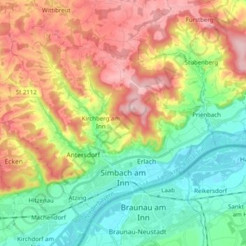
Nom : Carte topographique Simbach, altitude, relief.
Lieu : Simbach, Landkreis Rottal-Inn, Bayern, 84359, Deutschland (48.25305 12.94150 48.32081 13.08112)
Altitude moyenne : 425 m
Altitude minimum : 333 m
Altitude maximum : 555 m
Autres cartes topographiques
Cliquez sur une carte pour visualiser sa topographie, son altitude et son relief.
Plankenbach
Deutschland > Bayern > Landkreis Rottal-Inn > Dietersburg > Plankenbach
Altitude moyenne : 434 m
Perterting
Deutschland > Bayern > Landkreis Rottal-Inn > Falkenberg > Perterting
Altitude moyenne : 462 m
Rott
Deutschland > Bayern > Landkreis Rottal-Inn > Bayerbach > Bayerbach an der Rott > Voitl in der Au
Altitude moyenne : 358 m
Nindorf
Deutschland > Bayern > Landkreis Rottal-Inn > Bad Birnbach > Hirschbach
Altitude moyenne : 389 m
Obergrafendorf
Deutschland > Bayern > Landkreis Rottal-Inn
Das Kirchdorf Obergrafendorf liegt in einer Höhenlage von 366 Metern im Tal der Kollbach etwa auf halber Strecke zwischen Roßbach und Arnstorf an der Staatsstraße 2115.
Altitude moyenne : 388 m
Golling
Deutschland > Bayern > Landkreis Rottal-Inn > Simbach > Kirchberg am Inn
Altitude moyenne : 397 m
Nöham
Deutschland > Bayern > Landkreis Rottal-Inn
Adlhaid | Aichpoint | Aist | Altmannsberg | Asperting | Attenberg | Attenberg bei Nöham | Bachhub | Baumgarten | Berg | Bergham | Birnöd | Brand | Brandstetten | Breitenbach | Breitenöd | Bruckbach | Bruderöd | Buch | Büchl | Danten | Dellern | Dietersburg | Duröd | Ebenhof | Ed | Ed am Wald | Einpoint |…
Altitude moyenne : 442 m
Meier
Deutschland > Bayern > Landkreis Rottal-Inn > Pfarrkirchen > Untergrasensee
Altitude moyenne : 403 m
Aunham
Deutschland > Bayern > Landkreis Rottal-Inn > Bad Birnbach > Untertattenbach
Altitude moyenne : 383 m
Hirschbach
Deutschland > Bayern > Landkreis Rottal-Inn > Bad Birnbach > Hirschbach
Altitude moyenne : 396 m
Minihof
Deutschland > Bayern > Landkreis Rottal-Inn > Unterradlsbach > Minihof
Altitude moyenne : 414 m
Simbach
Deutschland > Bayern > Landkreis Rottal-Inn > Simbach > Burgholz > Ewigkeit
Altitude moyenne : 390 m
Naßberg
Deutschland > Bayern > Landkreis Rottal-Inn > Bad Birnbach > Lengham > Naßberg
Altitude moyenne : 374 m
Ed
Deutschland > Bayern > Landkreis Rottal-Inn > Simbach > Kirchberg am Inn > Ed
Altitude moyenne : 417 m