
Faire un don
Équipez-vous pour votre prochaine aventure :
En tant que Partenaire Amazon, ce site perçoit une commission sur les achats éligibles sans surcoût pour vous.
Carte topographique Meßstetten
Cliquez sur la carte pour afficher l’altitude.
Faire un don
Équipez-vous pour votre prochaine aventure :
En tant que Partenaire Amazon, ce site perçoit une commission sur les achats éligibles sans surcoût pour vous.
Meßstetten
Meßstetten (German: [mɛsˈʃtɛtn] ) is a town in the Zollernalbkreis district, in Baden-Württemberg, Germany, which is situated in the Swabian Jura, 24 km southeast of Balingen. At an altitude of 907 m (2,976 ft), Meßstetten is the highest city (of more than 10,000 inhabitants) in Germany. It is close to the Heuberg Training Area with the Lager Heuberg. Within the Heuberg Training Area there is the legendary Dreibannmarke, also called the "Bahn", a 17th-century border, which today marks the border between three different municipalities, formerly in the three states of Württemberg, Baden, and Hohenzollern. The meadow at the Dreibannmarke served as a stopping place for traveling merchants, wagons and craftsmen. With care it is possible to identify traces of the border. After the inauguration of the firing ranges, a meadow in Meßstetten was allocated as a camping site at the edge of the restricted area. Until 1835 merchandise was smuggled over the customs borders guarded by local hunters. Coffee smuggler Haux had was killed on 21 July 1831 in Pfaffental. Between 1934 and 1942, many men were sterilized because of "hereditary diseases". Under the program known as Aktion T4, the Nazis murdered mentally handicapped and mentally ill patients. These men and women were deported to the Grafeneck Killing Facility, where they were killed as "life unworthy of life". After the closure of Grafeneck in December 1940, a further deportation to the Hadamar Killing Facility occurred on 1941. After war a new city called Ostlandsiedlung was built.
Faire un don
Équipez-vous pour votre prochaine aventure :
En tant que Partenaire Amazon, ce site perçoit une commission sur les achats éligibles sans surcoût pour vous.
À propos de cette carte
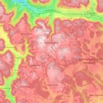
Nom : Carte topographique Meßstetten, altitude, relief.
Altitude moyenne : 862 m
Altitude minimum : 596 m
Altitude maximum : 989 m
Faire un don
Équipez-vous pour votre prochaine aventure :
En tant que Partenaire Amazon, ce site perçoit une commission sur les achats éligibles sans surcoût pour vous.
Autres cartes topographiques
Cliquez sur une carte pour visualiser sa topographie, son altitude et son relief.