
Faire un don
Équipez-vous pour votre prochaine aventure :
En tant que Partenaire Amazon, ce site perçoit une commission sur les achats éligibles sans surcoût pour vous.
Carte topographique Wessingen
Cliquez sur la carte pour afficher l’altitude.
Faire un don
Équipez-vous pour votre prochaine aventure :
En tant que Partenaire Amazon, ce site perçoit une commission sur les achats éligibles sans surcoût pour vous.
À propos de cette carte
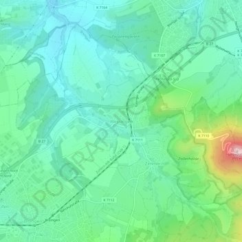
Nom : Carte topographique Wessingen, altitude, relief.
Altitude moyenne : 562 m
Altitude minimum : 475 m
Altitude maximum : 844 m
Faire un don
Équipez-vous pour votre prochaine aventure :
En tant que Partenaire Amazon, ce site perçoit une commission sur les achats éligibles sans surcoût pour vous.
Autres cartes topographiques
Cliquez sur une carte pour visualiser sa topographie, son altitude et son relief.
Rosenfeld
Germany > Baden-Württemberg > Zollernalbkreis > Rosenfeld > Isingen
Altitude moyenne : 599 m
Burladingen
Germany > Baden-Württemberg > Zollernalbkreis
The township (Stadt) of Burladingen is located in the Swabian Jura, specifically where the Middle Kuppenalb [de] transitions into the western Jura. Elevation above sea level in the municipal area varies from a low of 611 meters (2,005 ft) Normalnull (NN) to a high of 933 meters (3,061 ft).
Altitude moyenne : 784 m
Faire un don
Équipez-vous pour votre prochaine aventure :
En tant que Partenaire Amazon, ce site perçoit une commission sur les achats éligibles sans surcoût pour vous.
Meßstetten
Germany > Baden-Württemberg > Zollernalbkreis
Meßstetten (German: [mɛsˈʃtɛtn] ) is a town in the Zollernalbkreis district, in Baden-Württemberg, Germany, which is situated in the Swabian Jura, 24 km southeast of Balingen. At an altitude of 907 m (2,976 ft), Meßstetten is the highest city (of more than 10,000 inhabitants) in Germany. It is close to…
Altitude moyenne : 862 m
Dormettingen
Germany > Baden-Württemberg > Zollernalbkreis
The municipality (Gemeinde) of Dormettingen covers 6.55 square kilometers (2.53 sq mi) of the Zollernalb district of Baden-Württemberg, one of the Federal Republic of Germany's 16 States. It is physically located on the Little Heuberg [de], a plateau above the Schlichem where oil shale can be found in the…
Altitude moyenne : 641 m
Faire un don
Équipez-vous pour votre prochaine aventure :
En tant que Partenaire Amazon, ce site perçoit une commission sur les achats éligibles sans surcoût pour vous.
Albstadt
Germany > Baden-Württemberg > Zollernalbkreis
Albstadt is spread across a variety of hills and valleys, its elevation ranges between 614 m (2,014 ft) above sea level and 966 m (3,169 ft). One valley is the river Schmiecha, a left-hand tributary of the Danube, a second valley is the river of upper Eyach, a tributary of the Neckar.
Altitude moyenne : 814 m
Schömberg (Stadt)
Germany > Baden-Württemberg > Zollernalbkreis
The township (Stadt) of Schömberg is located in Zollernalbkreis, a district of the German state of Baden-Württemberg. It is physically located in the foothills of the Swabian Jura, specifically in the Upper Swabian Jura [de]. The main watercourse in the municipal area is the Schlichem, whose deeply-cut…
Altitude moyenne : 684 m
Faire un don
Équipez-vous pour votre prochaine aventure :
En tant que Partenaire Amazon, ce site perçoit une commission sur les achats éligibles sans surcoût pour vous.