
Carte topographique Mount Alford
Carte interactive
Cliquez sur la carte pour afficher l’altitude.
À propos de cette carte
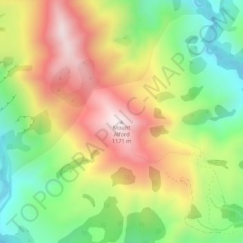
Nom : Carte topographique Mount Alford, altitude, relief.
Lieu : Mount Alford, Ashburton District, Canterbury, New Zealand (-43.58227 171.47303 -43.58217 171.47313)
Altitude moyenne : 806 m
Altitude minimum : 484 m
Altitude maximum : 1 174 m
Autres cartes topographiques
Cliquez sur une carte pour visualiser sa topographie, son altitude et son relief.
Methven
New Zealand > Canterbury > Ashburton District
Methven, Ashburton District, Canterbury, 7730, New Zealand
Altitude moyenne : 322 m
Wheatstone
New Zealand > Canterbury > Ashburton District
Wheatstone, Ashburton District, Canterbury, New Zealand
Altitude moyenne : 47 m
Ashburton
New Zealand > Canterbury > Ashburton District > Ashburton
Ashburton, Ashburton District, Canterbury, 7700, New Zealand
Altitude moyenne : 99 m