
Carte topographique Laramie Peak
Carte interactive
Cliquez sur la carte pour afficher l’altitude.
À propos de cette carte
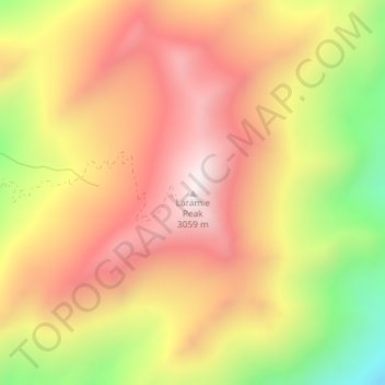
Nom : Carte topographique Laramie Peak, altitude, relief.
Lieu : Laramie Peak, Albany County, Wyoming, VS (42.26785 -105.44332 42.26795 -105.44322)
Altitude moyenne : 2 755 m
Altitude minimum : 2 259 m
Altitude maximum : 3 107 m
Autres cartes topographiques
Cliquez sur une carte pour visualiser sa topographie, son altitude et son relief.
Yellowstone National Park
Yellowstone National Park, Mary Mountain-Nez Perce, Teton County, Wyoming, VS
Altitude moyenne : 2 450 m
Rock Springs
VS > Wyoming > Rock Springs
Rock Springs, Sweetwater County, Wyoming, 82901, VS
Altitude moyenne : 2 011 m
Grand Teton National Park
Grand Teton National Park, Teton Park Road, Teton County, Wyoming, 83013, VS
Altitude moyenne : 2 409 m