
Carte topographique Shivling
Carte interactive
Cliquez sur la carte pour afficher l’altitude.
À propos de cette carte
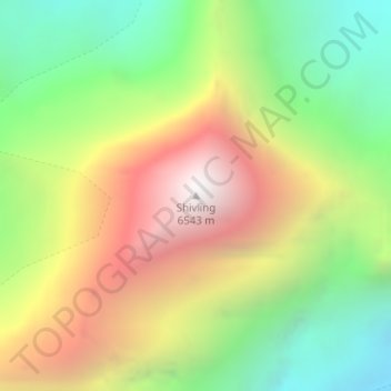
Nom : Carte topographique Shivling, altitude, relief.
Lieu : Shivling, Uttarkashi, Uttarakhand, India (30.87995 79.06306 30.88005 79.06316)
Altitude moyenne : 5 440 m
Altitude minimum : 4 597 m
Altitude maximum : 6 484 m
Autres cartes topographiques
Cliquez sur une carte pour visualiser sa topographie, son altitude et son relief.
Bhojwasa
India > Uttarakhand > Bhatwari
Bhojwasa, Bhatwari, Uttarkashi district, Uttarakhand, India
Altitude moyenne : 4 263 m
Pindar Glacier
Pindar Glacier, Bageshwar, Uttarakhand, India
Altitude moyenne : 4 447 m
Bāgeshwar
India > Uttarakhand > Bāgeshwar
Bāgeshwar, Bageshwar, Uttarakhand, 263642, India
Altitude moyenne : 1 154 m
Boora
India > Uttarakhand > Ghuni > Boora
Boora, Ghuni, Chamoli, Uttarakhand, India
Altitude moyenne : 2 195 m