
Carte topographique Uttarkashi
Carte interactive
Cliquez sur la carte pour afficher l’altitude.
À propos de cette carte
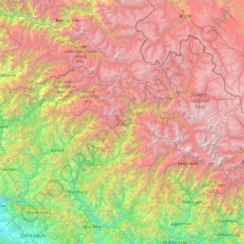
Nom : Carte topographique Uttarkashi, altitude, relief.
Lieu : Uttarkashi, Uttarakhand, India (30.47183 77.80955 31.45902 79.41725)
Altitude moyenne : 3 383 m
Altitude minimum : 497 m
Altitude maximum : 7 106 m
Autres cartes topographiques
Cliquez sur une carte pour visualiser sa topographie, son altitude et son relief.
Bhojwasa
India > Uttarakhand > Bhatwari
Bhojwasa, Bhatwari, Uttarkashi district, Uttarakhand, India
Altitude moyenne : 4 263 m
Pindar Glacier
Pindar Glacier, Bageshwar, Uttarakhand, India
Altitude moyenne : 4 447 m
Bāgeshwar
India > Uttarakhand > Bāgeshwar
Bāgeshwar, Bageshwar, Uttarakhand, 263642, India
Altitude moyenne : 1 154 m
Boora
India > Uttarakhand > Ghuni > Boora
Boora, Ghuni, Chamoli, Uttarakhand, India
Altitude moyenne : 2 195 m
Milam Glacier
Milam Glacier, Pithoragarh, Uttarakhand, India
Altitude moyenne : 5 223 m