
Carte topographique เขตบางคอแหลม
Carte interactive
Cliquez sur la carte pour afficher l’altitude.
À propos de cette carte
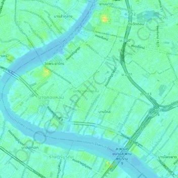
Nom : Carte topographique เขตบางคอแหลม, altitude, relief.
Lieu : เขตบางคอแหลม, Bangkok, 10120, Thailand (13.68278 100.48984 13.71232 100.53175)
Altitude moyenne : 6 m
Altitude minimum : -1 m
Altitude maximum : 21 m
Autres cartes topographiques
Cliquez sur une carte pour visualiser sa topographie, son altitude et son relief.
minburi park
Thailand > Bangkok > เขตมีนบุรี
minburi park, แขวงมีนบุรี, มีนบุรี, เขตมีนบุรี, Bangkok, 10510, Thailand
Altitude moyenne : 4 m