
Carte topographique La Massana
Carte interactive
Cliquez sur la carte pour afficher l’altitude.
À propos de cette carte
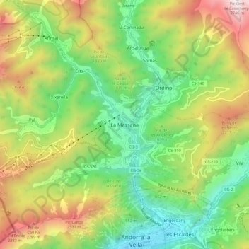
Nom : Carte topographique La Massana, altitude, relief.
Lieu : La Massana, AD400, Andorra (42.50420 1.47638 42.58420 1.55638)
Altitude moyenne : 1 667 m
Altitude minimum : 998 m
Altitude maximum : 2 718 m
Coma Pedrosa in the north-west of the parish is the highest point in the Principality of Andorra at 2,942 metres (9,652 ft), and has panoramic views of the Pyrenees. The mountain is also the site of the Coma Pedrosa Nature Reserve. It is covered by heavy snowfalls in winter, and usually retains some snow cover in summer. The four next-highest peaks are Medacorba (2914 m), Sanfonts (2888 m), Pla de l'Estany (2859 m), and Racofred (2837 m). The town of La Massana has an average elevation of 1,240 metres (4,070 ft) above sea-level. There are four lakes: Forcats, Montmantell, Estany Negre, and Les Truites Lake.
Autres cartes topographiques
Cliquez sur une carte pour visualiser sa topographie, son altitude et son relief.