
Carte topographique Pal
Carte interactive
Cliquez sur la carte pour afficher l’altitude.
À propos de cette carte
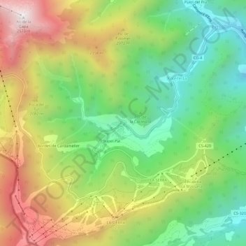
Nom : Carte topographique Pal, altitude, relief.
Lieu : Pal, AD400, Andorre (42.52580 1.45598 42.56580 1.49598)
Altitude moyenne : 1 830 m
Altitude minimum : 1 311 m
Altitude maximum : 2 553 m
Autres cartes topographiques
Cliquez sur une carte pour visualiser sa topographie, son altitude et son relief.
Andorre-la-Vieille
Andorre-la-Vieille (en catalan : Andorra la Vella) est le nom de l'une des sept paroisses (parròquia) et la capitale de la Principauté d'Andorre. La paroisse compte de nos jours un peu plus de 22 000 habitants, 19 000 pour la ville elle-même. Elle se situe sur la rivière Valira (ou Gran Valira), peu après…
Altitude moyenne : 1 270 m