
Faire un don
Équipez-vous pour votre prochaine aventure :
En tant que Partenaire Amazon, ce site perçoit une commission sur les achats éligibles sans surcoût pour vous.
Carte topographique West Sikkim District
Cliquez sur la carte pour afficher l’altitude.
Faire un don
Équipez-vous pour votre prochaine aventure :
En tant que Partenaire Amazon, ce site perçoit une commission sur les achats éligibles sans surcoût pour vous.
West Sikkim District
West Sikkim (now officially named as Geyzing District) is a district of the Indian state of Sikkim. Its headquarter is Geyzing, also known as Gyalshing. The district is a favourite with trekkers due to the high elevations. Other important towns include Pelling and Yuksom. Local people also call it as Pallo-Sikkim and Sano-Sikkim commonly.
Faire un don
Équipez-vous pour votre prochaine aventure :
En tant que Partenaire Amazon, ce site perçoit une commission sur les achats éligibles sans surcoût pour vous.
À propos de cette carte
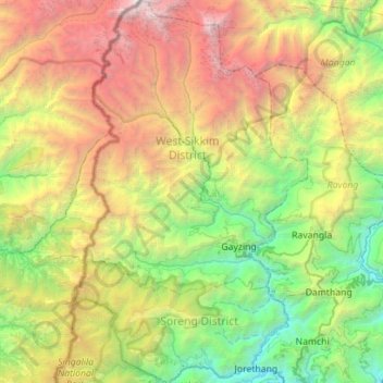
Nom : Carte topographique West Sikkim District, altitude, relief.
Lieu : West Sikkim District, Sikkim, India (27.11193 88.01203 27.60977 88.35827)
Altitude moyenne : 2 686 m
Altitude minimum : 292 m
Altitude maximum : 7 239 m
Faire un don
Équipez-vous pour votre prochaine aventure :
En tant que Partenaire Amazon, ce site perçoit une commission sur les achats éligibles sans surcoût pour vous.
Autres cartes topographiques
Cliquez sur une carte pour visualiser sa topographie, son altitude et son relief.
Faire un don
Équipez-vous pour votre prochaine aventure :
En tant que Partenaire Amazon, ce site perçoit une commission sur les achats éligibles sans surcoût pour vous.
Gangtok
India > Sikkim > Gangtok subdivision
Gangtok (Nepali: [gantok] gāntok, Sikkimese: [ɡaŋt̪ʰòk]) is the capital and the most populous city of the Indian state of Sikkim. The seat of eponymous district, Gangtok is in the eastern Himalayan range, at an elevation of 1,650 m (5,410 ft). The city's population of 100,000 consists of the three…
Altitude moyenne : 1 911 m
Faire un don
Équipez-vous pour votre prochaine aventure :
En tant que Partenaire Amazon, ce site perçoit une commission sur les achats éligibles sans surcoût pour vous.
Kangchenjunga
India > Sikkim > Chungthang
Kangchenjunga Main is the highest elevation of the Brahmaputra River basin, which forms part of the southeast Asian monsoon regime and is among the globally largest river basins. Kangchenjunga is one of six peaks above 8,000 m (26,000 ft) located in the basin of the Kosi River, which is among the largest…
Altitude moyenne : 7 725 m
Faire un don
Équipez-vous pour votre prochaine aventure :
En tant que Partenaire Amazon, ce site perçoit une commission sur les achats éligibles sans surcoût pour vous.
Gangtok
India > Sikkim > Gangtok subdivision
Gangtok (Nepali: gāntok, pronounced [gantok], Sikkimese: [ɡaŋt̪ʰòk]) is the capital and the most populous city of the Indian state of Sikkim. The seat of eponymous district, Gangtok is in the eastern Himalayan range, at an elevation of 1,650 m (5,410 ft). The city's population of 100,000 consists of the…
Altitude moyenne : 1 911 m
Faire un don
Équipez-vous pour votre prochaine aventure :
En tant que Partenaire Amazon, ce site perçoit une commission sur les achats éligibles sans surcoût pour vous.
Ravangla
Rabong or Ravangla is a small town with an elevation of 8000 feet located, near Namchi City in the Namchi district of the Indian state of Sikkim. It is connected by state highway to other major towns in the state and lies between Namchi, Pelling and Gangtok. It is the starting point for the trek to Maenam…
Altitude moyenne : 1 870 m
Faire un don
Équipez-vous pour votre prochaine aventure :
En tant que Partenaire Amazon, ce site perçoit une commission sur les achats éligibles sans surcoût pour vous.
Faire un don
Équipez-vous pour votre prochaine aventure :
En tant que Partenaire Amazon, ce site perçoit une commission sur les achats éligibles sans surcoût pour vous.
Kangchenjunga
India > Sikkim > Chungthang
Kangchenjunga Main is the highest elevation of the Brahmaputra River basin, which forms part of the southeast Asian monsoon regime and is among the globally largest river basins. Kangchenjunga is one of six peaks above 8,000 m (26,000 ft) located in the basin of the Kosi River, which is among the largest…
Altitude moyenne : 7 725 m
Faire un don
Équipez-vous pour votre prochaine aventure :
En tant que Partenaire Amazon, ce site perçoit une commission sur les achats éligibles sans surcoût pour vous.
Ravangla
Rabong or Ravangla is a small town with an elevation of 8000 feet located, near Namchi City in the Namchi district of the Indian state of Sikkim. It is connected by state highway to other major towns in the state and lies between Namchi, Pelling and Gangtok. It is the starting point for the trek to Maenam…
Altitude moyenne : 1 870 m
Faire un don
Équipez-vous pour votre prochaine aventure :
En tant que Partenaire Amazon, ce site perçoit une commission sur les achats éligibles sans surcoût pour vous.
Singtam
Singtam is located at 27°09′N 88°23′E / 27.15°N 88.38°E / 27.15; 88.38. It has an average elevation of 1396 feet. As the town lies on the bank of two rivers River Teesta and Ranikhola, so during Monsoon especially from June to September the volume of both the river increases heavily, as a…
Altitude moyenne : 894 m
Faire un don
Équipez-vous pour votre prochaine aventure :
En tant que Partenaire Amazon, ce site perçoit une commission sur les achats éligibles sans surcoût pour vous.
Kangchenjunga
India > Sikkim > Chungthang
Kangchenjunga Main is the highest elevation of the Brahmaputra River basin, which forms part of the southeast Asian monsoon regime and is among the globally largest river basins. Kangchenjunga is one of six peaks above 8,000 m (26,000 ft) located in the basin of the Kosi River, which is among the largest…
Altitude moyenne : 7 725 m
Faire un don
Équipez-vous pour votre prochaine aventure :
En tant que Partenaire Amazon, ce site perçoit une commission sur les achats éligibles sans surcoût pour vous.
Lachung
India > Sikkim > Chungthang
Lachung is a town and hill station in northeast Sikkim, India. It is located in the North Sikkim district near the border with Tibet. Lachung is at an elevation of about 9,600 feet (2,900 m) and at the confluence of the Lachen and Lachung Rivers, both tributaries of the River Teesta. The word Lachung means…
Altitude moyenne : 3 617 m