
Carte topographique Vert Lake
Cliquez sur la carte pour afficher l’altitude.
À propos de cette carte
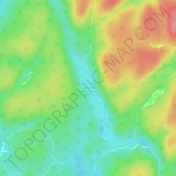
Nom : Carte topographique Vert Lake, altitude, relief.
Altitude moyenne : 476 m
Altitude minimum : 438 m
Altitude maximum : 527 m
Itinéraires Algoma District, randonnée, VTT, course à pied et activités de plein air
Autres cartes topographiques
Cliquez sur une carte pour visualiser sa topographie, son altitude et son relief.
Montreal River Harbour
Canada > Ontario > Algoma District > Unorganized North Algoma
Altitude moyenne : 212 m