
Carte topographique Jena
Carte interactive
Cliquez sur la carte pour afficher l’altitude.
À propos de cette carte
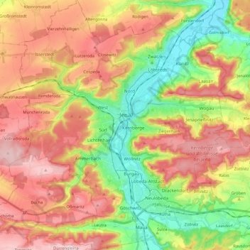
Nom : Carte topographique Jena, altitude, relief.
Lieu : Jena, Thuringia, Germany (50.85608 11.49896 50.98890 11.67299)
Altitude moyenne : 283 m
Altitude minimum : 131 m
Altitude maximum : 436 m
Jena is situated in a hilly landscape in eastern Thuringia at the Saale river, between the Harz mountains 85 km (53 mi) in the north, the Thuringian Forest/Thuringian Highland 50 km (31 mi) in the southwest and the Ore Mountains, 75 km (47 mi) in the southeast. The municipal terrain is hilly with rugged slopes at the valley's edges. The city centre is situated at 160 m of elevation, whereas the mountains on both sides of Saale valley rise up to 400 m. On the eastern side those are (from north to south): the Gleisberg near Kunitz, the Jenzig near Wogau, the Hausberg near Wenigenjena, the Kernberge near Wöllnitz, the Johannisberg near Lobeda and the Einsiedlerberg near Drackendorf. On the western side, there are the Jägersberg near Zwätzen, the Windknollen north of the city centre, the Tatzend west of the city centre, the Lichtenhainer Höhe near Lichtenhain, the Holzberg near Winzerla, the Jagdberg near Göschwitz and the Spitzenberg near Maua. The mountains belong to the geological formation of Ilm Saale Plate (Muschelkalk) and are relatively flat on their peaks but steep to the valleys in between. Due to its jagged surface, the municipal territory isn't very suitable for agriculture all the more since the most flat areas along the valley were built on during the 20th century. At the mountains is some forest of different leaf trees and pines.
Autres cartes topographiques
Cliquez sur une carte pour visualiser sa topographie, son altitude et son relief.
Geisa
Germany > Thuringia > Wartburgkreis > Geisa
Geisa, Wartburgkreis, Thuringia, 36419, Germany
Altitude moyenne : 332 m
Hartmannsdorf
Germany > Thuringia > Saale-Holzland-Kreis
Hartmannsdorf, Heideland-Elstertal-Schkölen, Saale-Holzland-Kreis, Thuringia, Germany
Altitude moyenne : 197 m
Großbreitenbach
Germany > Thuringia > Ilm-Kreis > Großbreitenbach
Großbreitenbach, Ilm-Kreis, Thuringia, Germany
Altitude moyenne : 596 m
Langenroda
Germany > Thuringia > Kyffhäuserkreis
Langenroda, Wiehe, Roßleben-Wiehe, Kyffhäuserkreis, Thuringia, Germany
Altitude moyenne : 236 m
Kella
Germany > Thuringia > Landkreis Eichsfeld
Kella, Ershausen/Geismar, Landkreis Eichsfeld, Thuringia, Germany
Altitude moyenne : 361 m
Ramsberg
Germany > Thuringia > Wartburgkreis > Lauterbach
Ramsberg, Lauterbach, Hainich-Werratal, Wartburgkreis, Thuringia, 99826, Germany
Altitude moyenne : 324 m
Schleusingen
Germany > Thuringia > Landkreis Hildburghausen
Schleusingen, Landkreis Hildburghausen, Thuringia, 98553, Germany
Altitude moyenne : 459 m
Artern
Germany > Thuringia > Kyffhäuserkreis
Artern, Kyffhäuserkreis, Thuringia, 06556, Germany
Altitude moyenne : 131 m
Schwabhausen
Germany > Thuringia > Landkreis Gotha
Schwabhausen, Drei Gleichen, Landkreis Gotha, Thuringia, Germany
Altitude moyenne : 352 m
Ichstedt
Germany > Thuringia > Kyffhäuserkreis > Bad Frankenhausen/Kyffhäuser
Ichstedt, Bad Frankenhausen/Kyffhäuser, Kyffhäuserkreis, Thuringia, Germany
Altitude moyenne : 175 m
Mühlhausen
Germany > Thuringia > Unstrut-Hainich-Kreis
Mühlhausen, Unstrut-Hainich-Kreis, Thuringia, Germany
Altitude moyenne : 288 m
Rotterode
Germany > Thuringia > Landkreis Schmalkalden-Meiningen > Steinbach-Hallenberg
Rotterode, Steinbach-Hallenberg, Landkreis Schmalkalden-Meiningen, Thuringia, 98587, Germany
Altitude moyenne : 570 m
Steinach
Germany > Thuringia > Landkreis Sonneberg
Steinach, Landkreis Sonneberg, Thuringia, 96523, Germany
Altitude moyenne : 653 m
Bad Salzungen
Germany > Thuringia > Wartburgkreis
Bad Salzungen, Wartburgkreis, Thuringia, Germany
Altitude moyenne : 347 m
Birkenfeld
Germany > Thuringia > Landkreis Hildburghausen > Hildburghausen
Birkenfeld, Hildburghausen, Landkreis Hildburghausen, Thuringia, 98669, Germany
Altitude moyenne : 418 m
Leinefelde
Germany > Thuringia > Landkreis Eichsfeld > Leinefelde-Worbis
Leinefelde, Leinefelde-Worbis, Landkreis Eichsfeld, Thuringia, 37327, Germany
Altitude moyenne : 360 m
Zeulenroda
Zeulenroda, Zeulenroda-Triebes, Greiz, Thuringia, 07937, Germany
Altitude moyenne : 406 m
Sondershausen
Germany > Thuringia > Kyffhäuserkreis
Sondershausen, Kyffhäuserland, Kyffhäuserkreis, Thuringia, 99707, Germany
Altitude moyenne : 273 m
Eisenberg
Germany > Thuringia > Saale-Holzland-Kreis
Eisenberg, Saale-Holzland-Kreis, Thuringia, 07607, Germany
Altitude moyenne : 305 m
Schleiz
Germany > Thuringia > Saale-Orla-Kreis
Schleiz, Saale-Orla-Kreis, Thuringia, 07907, Germany
Altitude moyenne : 479 m
Zschernitzsch
Germany > Thuringia > Altenburger Land > Schmölln
Zschernitzsch, Schmölln, Altenburger Land, Thuringia, 04626, Germany
Altitude moyenne : 241 m
Sömmerda
Germany > Thuringia > Landkreis Sömmerda
Sömmerda, Landkreis Sömmerda, Thuringia, 99610, Germany
Altitude moyenne : 155 m
Gerstungen
Germany > Thuringia > Wartburgkreis
Gerstungen, Wartburgkreis, Thuringia, 99834, Germany
Altitude moyenne : 302 m
Roßdorf
Germany > Thuringia > Landkreis Schmalkalden-Meiningen
Roßdorf, Breitungen/Werra, Landkreis Schmalkalden-Meiningen, Thuringia, Germany
Altitude moyenne : 436 m
Hermsdorf
Germany > Thuringia > Saale-Holzland-Kreis
Hermsdorf, Saale-Holzland-Kreis, Thuringia, Germany
Altitude moyenne : 339 m
Bad Liebenstein
Germany > Thuringia > Wartburgkreis
Bad Liebenstein, Wartburgkreis, Thuringia, Germany
Altitude moyenne : 424 m
Meiningen
Germany > Thuringia > Landkreis Schmalkalden-Meiningen > Meiningen
Meiningen, Kernstadt Meiningen, Meiningen, Landkreis Schmalkalden-Meiningen, Thuringia, 98617, Germany
Altitude moyenne : 394 m
Breitungen/Werra
Germany > Thuringia > Landkreis Schmalkalden-Meiningen
Breitungen/Werra, Landkreis Schmalkalden-Meiningen, Thuringia, Germany
Altitude moyenne : 345 m
Ohrdruf
Germany > Thuringia > Landkreis Gotha
Ohrdruf, Landkreis Gotha, Thuringia, 99885, Germany
Altitude moyenne : 518 m
Rudersdorf
Germany > Thuringia > Landkreis Sömmerda
Rudersdorf, Buttstädt, Landkreis Sömmerda, Thuringia, Germany
Altitude moyenne : 206 m
Höngeda
Germany > Thuringia > Unstrut-Hainich-Kreis > Mühlhausen
Höngeda, Mühlhausen, Unstrut-Hainich-Kreis, Thuringia, 99998, Germany
Altitude moyenne : 202 m
Dietzenrode/Vatterode
Germany > Thuringia > Landkreis Eichsfeld
Dietzenrode/Vatterode, Uder, Landkreis Eichsfeld, Thuringia, Germany
Altitude moyenne : 302 m
Zeutsch
Germany > Thuringia > Landkreis Saalfeld-Rudolstadt > Uhlstädt-Kirchhasel
Zeutsch, Uhlstädt-Kirchhasel, Landkreis Saalfeld-Rudolstadt, Thuringia, Germany
Altitude moyenne : 227 m
Burgtonna
Germany > Thuringia > Landkreis Gotha
Burgtonna, Tonna, Fahner Höhe, Landkreis Gotha, Thuringia, 99958, Germany
Altitude moyenne : 234 m
Voigtstedt
Germany > Thuringia > Kyffhäuserkreis > Artern
Voigtstedt, Artern, Kyffhäuserkreis, Thuringia, Germany
Altitude moyenne : 134 m
Tanna
Germany > Thuringia > Saale-Orla-Kreis
Tanna, Saale-Orla-Kreis, Thuringia, 07922, Germany
Altitude moyenne : 556 m
Hopfgarten
Germany > Thuringia > Landkreis Weimarer Land
Hopfgarten, Grammetal, Landkreis Weimarer Land, Thuringia, Germany
Altitude moyenne : 282 m
Walkes
Germany > Thuringia > Wartburgkreis > Geisa
Walkes, Geisa, Wartburgkreis, Thuringia, Germany
Altitude moyenne : 487 m
Unstrut-Hainich
Germany > Thuringia > Unstrut-Hainich-Kreis > Unstrut-Hainich
Unstrut-Hainich, Unstrut-Hainich-Kreis, Thuringia, 99991, Germany
Altitude moyenne : 279 m
Burg Ehrenstein
Germany > Thuringia > Ilm-Kreis > Stadtilm > Ehrenstein
Burg Ehrenstein, Ehrenstein, Stadtilm, Ilm-Kreis, Thuringia, 99326, Germany
Altitude moyenne : 415 m
Rodeberg
Germany > Thuringia > Unstrut-Hainich-Kreis > Rodeberg
Rodeberg, Südeichsfeld, Unstrut-Hainich-Kreis, Thuringia, Germany
Altitude moyenne : 422 m
Thamsbrück
Germany > Thuringia > Unstrut-Hainich-Kreis > Bad Langensalza > Thamsbrück
Thamsbrück, Bad Langensalza, Unstrut-Hainich-Kreis, Thuringia, 99947, Germany
Altitude moyenne : 189 m
Tonna
Germany > Thuringia > Landkreis Gotha
Tonna, Fahner Höhe, Landkreis Gotha, Thuringia, 99958, Germany
Altitude moyenne : 228 m