Carte topographique Ohrdruf
Carte interactive
Cliquez sur la carte pour afficher l’altitude.
À propos de cette carte
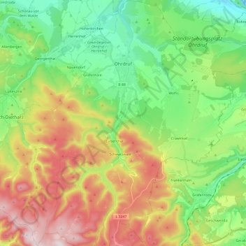
Nom : Carte topographique Ohrdruf, altitude, relief.
Lieu : Ohrdruf, Landkreis Gotha, Thuringia, 99885, Germany (50.71568 10.63015 50.86566 10.85992)
Altitude moyenne : 518 m
Altitude minimum : 288 m
Altitude maximum : 890 m
Autres cartes topographiques
Cliquez sur une carte pour visualiser sa topographie, son altitude et son relief.
Schwabhausen
Germany > Thuringia > Landkreis Gotha
Schwabhausen, Drei Gleichen, Landkreis Gotha, Thuringia, Germany
Altitude moyenne : 352 m
Burgtonna
Germany > Thuringia > Landkreis Gotha
Burgtonna, Tonna, Fahner Höhe, Landkreis Gotha, Thuringia, 99958, Germany
Altitude moyenne : 234 m
Tonna
Germany > Thuringia > Landkreis Gotha
Tonna, Fahner Höhe, Landkreis Gotha, Thuringia, 99958, Germany
Altitude moyenne : 228 m
Gotha
Germany > Thuringia > Landkreis Gotha
Gotha, Landkreis Gotha, Thuringia, 99867, Germany
Altitude moyenne : 320 m