
Faire un don
Équipez-vous pour votre prochaine aventure :
En tant que Partenaire Amazon, ce site perçoit une commission sur les achats éligibles sans surcoût pour vous.
Carte topographique Southern Alps
Cliquez sur la carte pour afficher l’altitude.
Faire un don
Équipez-vous pour votre prochaine aventure :
En tant que Partenaire Amazon, ce site perçoit une commission sur les achats éligibles sans surcoût pour vous.
À propos de cette carte
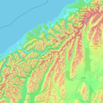
Nom : Carte topographique Southern Alps, altitude, relief.
Lieu : Southern Alps, West Coast, New Zealand (-44.42187 168.73809 -43.48165 170.39839)
Altitude moyenne : 770 m
Altitude minimum : -1 m
Altitude maximum : 3 586 m
Faire un don
Équipez-vous pour votre prochaine aventure :
En tant que Partenaire Amazon, ce site perçoit une commission sur les achats éligibles sans surcoût pour vous.
Autres cartes topographiques
Cliquez sur une carte pour visualiser sa topographie, son altitude et son relief.
Reefton
New Zealand > West Coast > Buller District
Located in the Inangahua Valley at an altitude of 194m, Reefton falls under the Köppen-Geiger climate classification of Cfb (Oceanic), though the town's sheltered inland location lends its climate less maritime influence than coastal areas; as such, Reefton has recorded both the extreme highest temperature of…
Altitude moyenne : 310 m
Kahurangi National Park
The special character of flora and fauna in the region was recognised prior to 1920. One particular example is the Gouland Downs, an area with unusual geology and vegetation, situated at around 600 m (2,000 ft) elevation to the west of Mt Perry. The Gouland Downs was one of eleven sanctuaries designated by the…
Altitude moyenne : 338 m
Faire un don
Équipez-vous pour votre prochaine aventure :
En tant que Partenaire Amazon, ce site perçoit une commission sur les achats éligibles sans surcoût pour vous.
Mount Aspiring National Park
Mount Aspiring National Park covers 3,562 square kilometres (1,375 mi2) at the southern end of the Southern Alps, directly to the west of Lake Wānaka, and is popular for tramping, walking and mountaineering. Mount Aspiring / Tititea, elevation 3,033 metres (9,951 ft) above sea level, gives the park its name.…
Altitude moyenne : 770 m
Westland Tai Poutini National Park
Westland Tai Poutini National Park covers 1,320 square kilometres (510 sq mi) exclusively on the western side of the South Island's main divide, making it New Zealand's fifth largest national park. The park covers a wide variety of environments, ranging from high alpine tundra near the park's border with…
Altitude moyenne : 685 m
Faire un don
Équipez-vous pour votre prochaine aventure :
En tant que Partenaire Amazon, ce site perçoit une commission sur les achats éligibles sans surcoût pour vous.
Greymouth
New Zealand > West Coast > Grey District
A combination of high intensity rainfall, high topographic relief and short steep rivers often leads to rapid flooding of low-lying land across the West Coast. Since its founding Greymouth has experienced two dozen floods by the Grey River, with many of the most significant being assigned names: for example,…
Altitude moyenne : 40 m
Faire un don
Équipez-vous pour votre prochaine aventure :
En tant que Partenaire Amazon, ce site perçoit une commission sur les achats éligibles sans surcoût pour vous.
Faire un don
Équipez-vous pour votre prochaine aventure :
En tant que Partenaire Amazon, ce site perçoit une commission sur les achats éligibles sans surcoût pour vous.
Faire un don
Équipez-vous pour votre prochaine aventure :
En tant que Partenaire Amazon, ce site perçoit une commission sur les achats éligibles sans surcoût pour vous.
Franz Josef Glacier
New Zealand > West Coast > Westland District
The névé or snowfield at the head of Franz Josef Glacier is over 2,500 metres (8,200 ft) above sea level and 20 square kilometres (7.7 sq mi) in area. This wide névé, which is over 300 metres (980 ft) deep, feeds large amounts of compacted snow into a steep and narrow valley which drops quickly to very low…
Altitude moyenne : 1 709 m
Faire un don
Équipez-vous pour votre prochaine aventure :
En tant que Partenaire Amazon, ce site perçoit une commission sur les achats éligibles sans surcoût pour vous.
Faire un don
Équipez-vous pour votre prochaine aventure :
En tant que Partenaire Amazon, ce site perçoit une commission sur les achats éligibles sans surcoût pour vous.
Faire un don
Équipez-vous pour votre prochaine aventure :
En tant que Partenaire Amazon, ce site perçoit une commission sur les achats éligibles sans surcoût pour vous.
Mount Aspiring
New Zealand > West Coast > Westland District
Mount Aspiring / Tititea is New Zealand's 23rd-highest mountain. The peak's altitude of 3,033 metres (9,951 ft) makes it the country's highest outside the Aoraki / Mount Cook National Park region.
Altitude moyenne : 2 257 m
Faire un don
Équipez-vous pour votre prochaine aventure :
En tant que Partenaire Amazon, ce site perçoit une commission sur les achats éligibles sans surcoût pour vous.
Buller River Mouth Wildlife Refuge
New Zealand > West Coast > Buller District > Westport
Altitude moyenne : 5 m
Faire un don
Équipez-vous pour votre prochaine aventure :
En tant que Partenaire Amazon, ce site perçoit une commission sur les achats éligibles sans surcoût pour vous.
Faire un don
Équipez-vous pour votre prochaine aventure :
En tant que Partenaire Amazon, ce site perçoit une commission sur les achats éligibles sans surcoût pour vous.
Faire un don
Équipez-vous pour votre prochaine aventure :
En tant que Partenaire Amazon, ce site perçoit une commission sur les achats éligibles sans surcoût pour vous.
Fox Glacier
New Zealand > West Coast > Westland District
Chancellor Hut was built in 1930–31 on the southwest face of Chancellor Ridge, now 200 m above the glacier. Planned by mountain guides Alec and Peter Graham in 1929, all the materials had to be packed up Fox Glacier manually in 1930 in the days before helicopter airlifts. It is the oldest remaining mountain…
Altitude moyenne : 1 848 m
Faire un don
Équipez-vous pour votre prochaine aventure :
En tant que Partenaire Amazon, ce site perçoit une commission sur les achats éligibles sans surcoût pour vous.
Volta Glacier
New Zealand > West Coast > Westland District
It is split into upper and lower glaciers which are connected by an icefall. The Upper Volta Glacier is between 1,600–2,000 m (5,200–6,600 ft) in altitude and is surrounded by the 3 peaks of Glacier Dome, Pickelhaube and Fastness Peak, while the Lower Volta Glacier sits directly under the North side of…
Altitude moyenne : 1 550 m
Faire un don
Équipez-vous pour votre prochaine aventure :
En tant que Partenaire Amazon, ce site perçoit une commission sur les achats éligibles sans surcoût pour vous.
Garden of Eden Ice Plateau
New Zealand > West Coast > Ashburton District
Unlike most glaciers in New Zealand, the Garden of Eden is aligned east-west across both sides of the main divide of the Southern Alps / Kā Tiritiri o te Moana. The eastern reaches of the plateau are the highest point, reaching an altitude of around 2,300 m (7,500 ft) in the area south of Newton Peak. The…
Altitude moyenne : 1 707 m
Faire un don
Équipez-vous pour votre prochaine aventure :
En tant que Partenaire Amazon, ce site perçoit une commission sur les achats éligibles sans surcoût pour vous.
Dart Glacier
New Zealand > West Coast > Queenstown-Lakes District
The topography and climate of the Dart Glacier make it particularly responsive to changes in conditions. Since 1915, the glacier has retreated approximately 3.5 kilometres (2.2 mi), with historical records from the time showing the glacier extending further down the Dart Valley, connecting with the Hesse and…
Altitude moyenne : 1 850 m
Faire un don
Équipez-vous pour votre prochaine aventure :
En tant que Partenaire Amazon, ce site perçoit une commission sur les achats éligibles sans surcoût pour vous.
Faire un don
Équipez-vous pour votre prochaine aventure :
En tant que Partenaire Amazon, ce site perçoit une commission sur les achats éligibles sans surcoût pour vous.
Reefton
New Zealand > West Coast > Buller District
Located in the Inangahua Valley at an altitude of 194m, Reefton falls under the Köppen-Geiger climate classification of Cfb (Oceanic), though the town's sheltered inland location lends its climate less maritime influence than coastal areas; as such, Reefton has recorded both the extreme highest temperature of…
Altitude moyenne : 310 m
Franz Josef Glacier
New Zealand > West Coast > Westland District
The névé or snowfield at the head of Franz Josef Glacier is over 2,500 metres (8,200 ft) above sea level and 20 square kilometres (7.7 sq mi) in area. This wide névé, which is over 300 metres (980 ft) deep, feeds large amounts of compacted snow into a steep and narrow valley which drops quickly to very low…
Altitude moyenne : 1 709 m
Faire un don
Équipez-vous pour votre prochaine aventure :
En tant que Partenaire Amazon, ce site perçoit une commission sur les achats éligibles sans surcoût pour vous.
Faire un don
Équipez-vous pour votre prochaine aventure :
En tant que Partenaire Amazon, ce site perçoit une commission sur les achats éligibles sans surcoût pour vous.
Fox Glacier
New Zealand > West Coast > Westland District
Chancellor Hut was built in 1930–31 on the southwest face of Chancellor Ridge, now 200 m above the glacier. Planned by mountain guides Alec and Peter Graham in 1929, all the materials had to be packed up Fox Glacier manually in 1930 in the days before helicopter airlifts. It is the oldest remaining mountain…
Altitude moyenne : 1 848 m
Faire un don
Équipez-vous pour votre prochaine aventure :
En tant que Partenaire Amazon, ce site perçoit une commission sur les achats éligibles sans surcoût pour vous.
Faire un don
Équipez-vous pour votre prochaine aventure :
En tant que Partenaire Amazon, ce site perçoit une commission sur les achats éligibles sans surcoût pour vous.
Faire un don
Équipez-vous pour votre prochaine aventure :
En tant que Partenaire Amazon, ce site perçoit une commission sur les achats éligibles sans surcoût pour vous.
Faire un don
Équipez-vous pour votre prochaine aventure :
En tant que Partenaire Amazon, ce site perçoit une commission sur les achats éligibles sans surcoût pour vous.
Fox Glacier
New Zealand > West Coast > Westland District
Chancellor Hut was built in 1930–31 on the southwest face of Chancellor Ridge, now 200 m above the glacier. Planned by mountain guides Alec and Peter Graham in 1929, all the materials had to be packed up Fox Glacier manually in 1930 in the days before helicopter airlifts. It is the oldest remaining mountain…
Altitude moyenne : 1 848 m
Reefton
New Zealand > West Coast > Buller District
Located in the Inangahua Valley at an altitude of 194m, Reefton falls under the Köppen-Geiger climate classification of Cfb (Oceanic), though the town's sheltered inland location lends its climate less maritime influence than coastal areas; as such, Reefton has recorded both the extreme highest temperature of…
Altitude moyenne : 310 m
Faire un don
Équipez-vous pour votre prochaine aventure :
En tant que Partenaire Amazon, ce site perçoit une commission sur les achats éligibles sans surcoût pour vous.
Greymouth
New Zealand > West Coast > Grey District
A combination of high intensity rainfall, high topographic relief and short steep rivers often leads to rapid flooding of low-lying land across the West Coast. Since its founding Greymouth has experienced two dozen floods by the Grey River, with many of the most significant being assigned names: for example,…
Altitude moyenne : 40 m
Faire un don
Équipez-vous pour votre prochaine aventure :
En tant que Partenaire Amazon, ce site perçoit une commission sur les achats éligibles sans surcoût pour vous.