
Faire un don
Équipez-vous pour votre prochaine aventure :
En tant que Partenaire Amazon, ce site perçoit une commission sur les achats éligibles sans surcoût pour vous.
Carte topographique Reefton
Cliquez sur la carte pour afficher l’altitude.
Faire un don
Équipez-vous pour votre prochaine aventure :
En tant que Partenaire Amazon, ce site perçoit une commission sur les achats éligibles sans surcoût pour vous.
Reefton
Located in the Inangahua Valley at an altitude of 194m, Reefton falls under the Köppen-Geiger climate classification of Cfb (Oceanic), though the town's sheltered inland location lends its climate less maritime influence than coastal areas; as such, Reefton has recorded both the extreme highest temperature of 33.7 °C (92.7 °F) and the extreme lowest temperature of -8.5 °C (16.7 °F) in the West Coast region. At an average temperature of 17.4 °C (63.3 °F), February is the warmest month. July is the coldest month, at 5.4 °C (41.7 °F). Reefton's average annual temperature is 11.7 °C. Due to the town's inland location, summer afternoons are often considerably warmer in Reefton than coastal locations such as Greymouth or Westport, and it is not uncommon for winter mornings to be several degrees colder; nightly inversions of temperature are common due to the local geography, which encourages frequent periods of calm air. An average of 24 days per year will exceed 25 °C (77 °F); during an average winter, Reefton can expect to see 46 days of air frost and 61 days of ground frost. The Reefton area is the driest in the West Coast; this is largely due to the rain-shadow effect of the Paparoa Range.
Faire un don
Équipez-vous pour votre prochaine aventure :
En tant que Partenaire Amazon, ce site perçoit une commission sur les achats éligibles sans surcoût pour vous.
À propos de cette carte
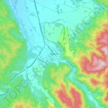
Nom : Carte topographique Reefton, altitude, relief.
Lieu : Reefton, Buller District, West Coast, 7830, New Zealand (-42.15594 171.82346 -42.07594 171.90346)
Altitude moyenne : 310 m
Altitude minimum : 156 m
Altitude maximum : 713 m
Faire un don
Équipez-vous pour votre prochaine aventure :
En tant que Partenaire Amazon, ce site perçoit une commission sur les achats éligibles sans surcoût pour vous.
Autres cartes topographiques
Cliquez sur une carte pour visualiser sa topographie, son altitude et son relief.
Faire un don
Équipez-vous pour votre prochaine aventure :
En tant que Partenaire Amazon, ce site perçoit une commission sur les achats éligibles sans surcoût pour vous.
Faire un don
Équipez-vous pour votre prochaine aventure :
En tant que Partenaire Amazon, ce site perçoit une commission sur les achats éligibles sans surcoût pour vous.
Buller River Mouth Wildlife Refuge
New Zealand > West Coast > Buller District > Westport
Altitude moyenne : 5 m
Faire un don
Équipez-vous pour votre prochaine aventure :
En tant que Partenaire Amazon, ce site perçoit une commission sur les achats éligibles sans surcoût pour vous.