
Carte topographique Benbrook Lake
Carte interactive
Cliquez sur la carte pour afficher l’altitude.
À propos de cette carte
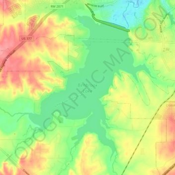
Nom : Carte topographique Benbrook Lake, altitude, relief.
Altitude moyenne : 230 m
Altitude minimum : 191 m
Altitude maximum : 276 m
Construction of Benbrook dam began in May 1947, and was practically completed when floodgates were closed and deliberate impoundment was begun in September 1952. The cost to build the lake was $14.5 million ($112 million in 2007 dollars). The rolled-earth embankment is 9,130 feet (2,783 m) in length, including the concrete spillway, and rises 130 feet (39.6 m) above the streambed to an elevation of 747 feet (227.7 m) above sea level. A pair of 6.5-foot (2.0 m) × 13-foot (4.0 m) sliding gates operated by electric cable hoists controls the floodwater releases through the 13-foot-diameter conduit (4.0 m) . Two 30-inch-diameter pipes (0.76 m) are provided for low-flow releases to maintain downstream river flows. The concrete spillway for uncontrolled releases is 500 feet (152 m) long, with a 100-foot notch (30 m) in its center.
Autres cartes topographiques
Cliquez sur une carte pour visualiser sa topographie, son altitude et son relief.
Summerfields/Chisholm Park
United States > Texas > Tarrant County > Fort Worth
Summerfields/Chisholm Park, Fort Worth, Tarrant County, Texas, United States
Altitude moyenne : 203 m
Tarrant
United States > Texas > Tarrant County > Fort Worth
Tarrant, Fort Worth, Tarrant County, Texas, 76005, United States
Altitude moyenne : 155 m
Melody Hills
United States > Texas > Tarrant County > Fort Worth
Melody Hills, Fort Worth, Tarrant County, Texas, 76161, United States
Altitude moyenne : 191 m
Fort Worth
United States > Texas > Tarrant County > Fort Worth
Fort Worth, Tarrant County, Texas, 76102, United States
Altitude moyenne : 202 m
Rendon
United States > Texas > Tarrant County > Fort Worth
Rendon, Fort Worth, Tarrant County, Texas, United States
Altitude moyenne : 221 m
Will Rogers Memorial Center
United States > Texas > Tarrant County > Fort Worth
Will Rogers Memorial Center, Fort Worth, Tarrant County, Texas, United States
Altitude moyenne : 181 m
Magnolia Micro Park
United States > Texas > Tarrant County > Fort Worth
Magnolia Micro Park, Fort Worth, Tarrant County, Texas, United States
Altitude moyenne : 195 m