
Carte topographique Fort Worth
Carte interactive
Cliquez sur la carte pour afficher l’altitude.
À propos de cette carte
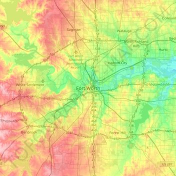
Nom : Carte topographique Fort Worth, altitude, relief.
Lieu : Fort Worth, Tarrant County, Texas, 76102, United States (32.59318 -97.49275 32.91318 -97.17275)
Altitude moyenne : 202 m
Altitude minimum : 139 m
Altitude maximum : 279 m
Autres cartes topographiques
Cliquez sur une carte pour visualiser sa topographie, son altitude et son relief.
Summerfields/Chisholm Park
United States > Texas > Tarrant County > Fort Worth
Summerfields/Chisholm Park, Fort Worth, Tarrant County, Texas, United States
Altitude moyenne : 203 m
Tarrant
United States > Texas > Tarrant County > Fort Worth
Tarrant, Fort Worth, Tarrant County, Texas, 76005, United States
Altitude moyenne : 155 m
Melody Hills
United States > Texas > Tarrant County > Fort Worth
Melody Hills, Fort Worth, Tarrant County, Texas, 76161, United States
Altitude moyenne : 191 m
Benbrook Lake
United States > Texas > Tarrant County > Fort Worth
Benbrook Lake, Fort Worth, Tarrant County, Texas, United States
Altitude moyenne : 230 m
Rendon
United States > Texas > Tarrant County > Fort Worth
Rendon, Fort Worth, Tarrant County, Texas, United States
Altitude moyenne : 221 m
Will Rogers Memorial Center
United States > Texas > Tarrant County > Fort Worth
Will Rogers Memorial Center, Fort Worth, Tarrant County, Texas, United States
Altitude moyenne : 181 m
Magnolia Micro Park
United States > Texas > Tarrant County > Fort Worth
Magnolia Micro Park, Fort Worth, Tarrant County, Texas, United States
Altitude moyenne : 195 m