
Carte topographique Lakewood
Carte interactive
Cliquez sur la carte pour afficher l’altitude.
À propos de cette carte
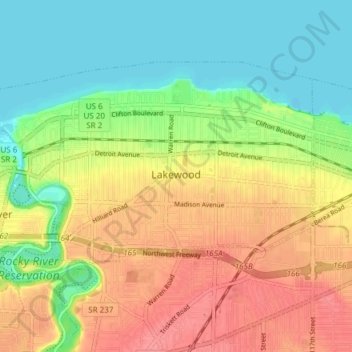
Nom : Carte topographique Lakewood, altitude, relief.
Lieu : Lakewood, Cuyahoga County, Ohio, 44107, United States (41.46325 -81.84398 41.50005 -81.76858)
Altitude moyenne : 203 m
Altitude minimum : 171 m
Altitude maximum : 240 m
Autres cartes topographiques
Cliquez sur une carte pour visualiser sa topographie, son altitude et son relief.
Solon
United States > Ohio > Cuyahoga County
Solon, Cuyahoga County, Ohio, 44139, United States
Altitude moyenne : 314 m
Chagrin Falls
United States > Ohio > Cuyahoga County
Chagrin Falls, Cuyahoga County, Ohio, United States
Altitude moyenne : 305 m
Richmond Heights
United States > Ohio > Cuyahoga County
Richmond Heights, Cuyahoga County, Ohio, United States
Altitude moyenne : 252 m
Beachwood
United States > Ohio > Cuyahoga County
Beachwood, Cuyahoga County, Ohio, 44122, United States
Altitude moyenne : 344 m
Cleveland
United States > Ohio > Cuyahoga County
Cleveland, Cuyahoga County, Ohio, United States
Altitude moyenne : 215 m
Broadview Heights
United States > Ohio > Cuyahoga County
Broadview Heights, Cuyahoga County, Ohio, 44147, United States
Altitude moyenne : 351 m
North Royalton
United States > Ohio > Cuyahoga County
North Royalton, Cuyahoga County, Ohio, 44133, United States
Altitude moyenne : 333 m
Bedford Heights
United States > Ohio > Cuyahoga County
Bedford Heights, Cuyahoga County, Ohio, United States
Altitude moyenne : 310 m
Parma
United States > Ohio > Cuyahoga County > Parma
Parma, Cuyahoga County, Ohio, United States
Altitude moyenne : 282 m
Cuyahoga Heights
United States > Ohio > Cuyahoga County > Cuyahoga Heights
Cuyahoga Heights, Cuyahoga County, Ohio, United States
Altitude moyenne : 222 m
Brooklyn
United States > Ohio > Cuyahoga County > Brooklyn
Brooklyn, Cuyahoga County, Ohio, 44144, United States
Altitude moyenne : 230 m
Seven Hills
United States > Ohio > Cuyahoga County
Seven Hills, Cuyahoga County, Ohio, 44131, United States
Altitude moyenne : 288 m
Mayfield Heights
United States > Ohio > Cuyahoga County > Mayfield Heights
Mayfield Heights, Cuyahoga County, Ohio, 44040, United States
Altitude moyenne : 331 m
Walton Hills
United States > Ohio > Cuyahoga County > Walton Hills
Walton Hills, Cuyahoga County, Ohio, United States
Altitude moyenne : 265 m
Euclid
United States > Ohio > Cuyahoga County > Euclid
Euclid, Cuyahoga County, Ohio, United States
Altitude moyenne : 206 m
Linndale
United States > Ohio > Cuyahoga County > Linndale
Linndale, Cuyahoga County, Ohio, United States
Altitude moyenne : 232 m
Pepper Pike
United States > Ohio > Cuyahoga County > Pepper Pike
Pepper Pike, Cuyahoga County, Ohio, United States
Altitude moyenne : 332 m
Garfield Heights
United States > Ohio > Cuyahoga County > Garfield Heights
Garfield Heights, Cuyahoga County, Ohio, 44125, United States
Altitude moyenne : 251 m
Shaker Heights
United States > Ohio > Cuyahoga County
Shaker Heights, Cuyahoga County, Ohio, 44120, United States
Altitude moyenne : 323 m
Cleveland
United States > Ohio > Cuyahoga County > Cleveland
Cleveland, Cuyahoga County, Ohio, 44114, United States
Altitude moyenne : 219 m
Strongsville
United States > Ohio > Cuyahoga County
Strongsville, Cuyahoga County, Ohio, United States
Altitude moyenne : 279 m
Berea
United States > Ohio > Cuyahoga County
Berea, Cuyahoga County, Ohio, 44017, United States
Altitude moyenne : 242 m
West Dover
United States > Ohio > Cuyahoga County > Westlake > West Dover
West Dover, Westlake, Cuyahoga County, Ohio, 4415, United States
Altitude moyenne : 194 m
Gates Mills
United States > Ohio > Cuyahoga County > Gates Mills
Gates Mills, Cuyahoga County, Ohio, 44040:44099, United States
Altitude moyenne : 302 m
Rocky River
United States > Ohio > Cuyahoga County
Rocky River, Cuyahoga County, Ohio, 44116, United States
Altitude moyenne : 205 m
Moreland Hills
United States > Ohio > Cuyahoga County > Moreland Hills
Moreland Hills, Cuyahoga County, Ohio, United States
Altitude moyenne : 307 m
Westlake
United States > Ohio > Cuyahoga County
Westlake, Cuyahoga County, Ohio, 44145, United States
Altitude moyenne : 218 m