
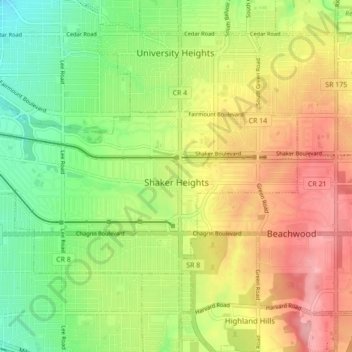
Carte topographique Shaker Heights
Carte interactive
Cliquez sur la carte pour afficher l’altitude.
À propos de cette carte
Nom : Carte topographique Shaker Heights, altitude, relief.
Lieu : Shaker Heights, Cuyahoga County, Ohio, 44120, United States (41.45706 -81.59376 41.49295 -81.50712)
Altitude moyenne : 323 m
Altitude minimum : 267 m
Altitude maximum : 386 m
Shaker Heights was established in 1909, and incorporated as a village in 1912. Shaker Heights is home to the oldest house in Cuyahoga County, built in 1817 by Moses Warren. The name "Shaker Heights" has origins in two local sources. The community was laid out on land formerly owned by the North Union Community of the United Society of Believers in Christ's Second Appearing, more commonly known as Shakers. "Heights" refers to the plateau east of Cleveland that rises sharply in elevation from 582 feet above sea level at the base of the Cedar Glen Parkway rising to 950 feet above sea level in nearby Cleveland Heights; Shaker Heights' elevation is 1050 feet above sea level.
Autres cartes topographiques
Cliquez sur une carte pour visualiser sa topographie, son altitude et son relief.
Solon
United States > Ohio > Cuyahoga County
Solon, Cuyahoga County, Ohio, 44139, United States
Altitude moyenne : 314 m
Chagrin Falls
United States > Ohio > Cuyahoga County
Chagrin Falls, Cuyahoga County, Ohio, United States
Altitude moyenne : 305 m
Richmond Heights
United States > Ohio > Cuyahoga County
Richmond Heights, Cuyahoga County, Ohio, United States
Altitude moyenne : 252 m
Beachwood
United States > Ohio > Cuyahoga County
Beachwood, Cuyahoga County, Ohio, 44122, United States
Altitude moyenne : 344 m
Cleveland
United States > Ohio > Cuyahoga County
Cleveland, Cuyahoga County, Ohio, United States
Altitude moyenne : 215 m
Broadview Heights
United States > Ohio > Cuyahoga County
Broadview Heights, Cuyahoga County, Ohio, 44147, United States
Altitude moyenne : 351 m
North Royalton
United States > Ohio > Cuyahoga County
North Royalton, Cuyahoga County, Ohio, 44133, United States
Altitude moyenne : 333 m
Bedford Heights
United States > Ohio > Cuyahoga County
Bedford Heights, Cuyahoga County, Ohio, United States
Altitude moyenne : 310 m
Parma
United States > Ohio > Cuyahoga County > Parma
Parma, Cuyahoga County, Ohio, United States
Altitude moyenne : 282 m
Cuyahoga Heights
United States > Ohio > Cuyahoga County > Cuyahoga Heights
Cuyahoga Heights, Cuyahoga County, Ohio, United States
Altitude moyenne : 222 m
Brooklyn
United States > Ohio > Cuyahoga County > Brooklyn
Brooklyn, Cuyahoga County, Ohio, 44144, United States
Altitude moyenne : 230 m
Seven Hills
United States > Ohio > Cuyahoga County
Seven Hills, Cuyahoga County, Ohio, 44131, United States
Altitude moyenne : 288 m
Mayfield Heights
United States > Ohio > Cuyahoga County > Mayfield Heights
Mayfield Heights, Cuyahoga County, Ohio, 44040, United States
Altitude moyenne : 331 m
Walton Hills
United States > Ohio > Cuyahoga County > Walton Hills
Walton Hills, Cuyahoga County, Ohio, United States
Altitude moyenne : 265 m
Euclid
United States > Ohio > Cuyahoga County > Euclid
Euclid, Cuyahoga County, Ohio, United States
Altitude moyenne : 206 m
Linndale
United States > Ohio > Cuyahoga County > Linndale
Linndale, Cuyahoga County, Ohio, United States
Altitude moyenne : 232 m
Pepper Pike
United States > Ohio > Cuyahoga County > Pepper Pike
Pepper Pike, Cuyahoga County, Ohio, United States
Altitude moyenne : 332 m
Garfield Heights
United States > Ohio > Cuyahoga County > Garfield Heights
Garfield Heights, Cuyahoga County, Ohio, 44125, United States
Altitude moyenne : 251 m
Cleveland
United States > Ohio > Cuyahoga County > Cleveland
Cleveland, Cuyahoga County, Ohio, 44114, United States
Altitude moyenne : 219 m
Strongsville
United States > Ohio > Cuyahoga County
Strongsville, Cuyahoga County, Ohio, United States
Altitude moyenne : 279 m
Berea
United States > Ohio > Cuyahoga County
Berea, Cuyahoga County, Ohio, 44017, United States
Altitude moyenne : 242 m
West Dover
United States > Ohio > Cuyahoga County > Westlake > West Dover
West Dover, Westlake, Cuyahoga County, Ohio, 4415, United States
Altitude moyenne : 194 m
Gates Mills
United States > Ohio > Cuyahoga County > Gates Mills
Gates Mills, Cuyahoga County, Ohio, 44040:44099, United States
Altitude moyenne : 302 m
Rocky River
United States > Ohio > Cuyahoga County
Rocky River, Cuyahoga County, Ohio, 44116, United States
Altitude moyenne : 205 m
Moreland Hills
United States > Ohio > Cuyahoga County > Moreland Hills
Moreland Hills, Cuyahoga County, Ohio, United States
Altitude moyenne : 307 m
Lakewood
United States > Ohio > Cuyahoga County
Lakewood, Cuyahoga County, Ohio, 44107, United States
Altitude moyenne : 203 m
Westlake
United States > Ohio > Cuyahoga County
Westlake, Cuyahoga County, Ohio, 44145, United States
Altitude moyenne : 218 m