
Carte topographique Semarang
Cliquez sur la carte pour afficher l’altitude.
Semarang
Semarang is located on the northern coast of Java. The city of Semarang is one of the important cities located on the north coast of Java and as the main hub connecting Jakarta and Surabaya, and cities in the southern interior of Java Surakarta and Yogyakarta. Semarang City has a height ranging from 2 m (6.6 ft) below sea level up to 340 m (1,120 ft) above sea level with a slope of 0%–45%. Semarang City is a city that has a unique topographic condition in the form of a narrow lowland area and hilly areas extending from the west side to the east side of Semarang City. The city is located about 558 km (347 mi) east of Jakarta and 312 km (194 mi) west of Surabaya.
À propos de cette carte
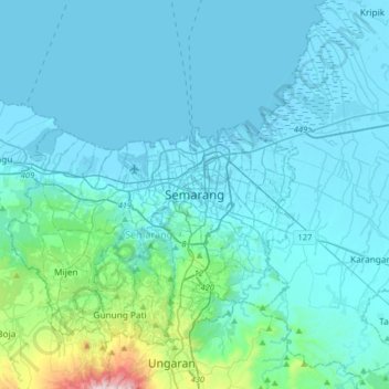
Nom : Carte topographique Semarang, altitude, relief.
Lieu : Semarang, Central Java, Java, Indonesia (-7.15040 110.26291 -6.83040 110.58291)
Altitude moyenne : 88 m
Altitude minimum : -1 m
Altitude maximum : 971 m
Autres cartes topographiques
Cliquez sur une carte pour visualiser sa topographie, son altitude et son relief.
Semarang
Semarang is located on the northern coast of Java. The city of Semarang is one of the important cities located on the north coast of Java and as the main hub connecting Jakarta and Surabaya, and cities in the southern interior of Java Surakarta and Yogyakarta. Semarang City has a height ranging from 2 m (6.6…
Altitude moyenne : 107 m
Wonosobo
Wonosobo has an elevation moderated tropical rainforest climate (Af) with moderate rainfall from July to September and heavy to very heavy rainfall in the remaining months. The following climate data is for the town of Wonosobo.
Altitude moyenne : 876 m
Temanggung
Temanggung Regency is located on the volcanic Dieng Plateau with an average elevation between 500 and 1450 meters. It is landlocked. The volcanoes Mount Sundoro and Mount Sumbing rise on its border with the Wonosobo Regency. Its major drainage system is the Progo River and its tributaries.
Altitude moyenne : 771 m
Semarang
Semarang is located on the northern coast of Java. The city of Semarang is one of the most important cities located on the north coast of Java and is the main hub connecting Jakarta and Surabaya, and cities in the southern interior of Java Surakarta and Yogyakarta. Semarang City has a height ranging from 2 m…
Altitude moyenne : 107 m
Semarang
Semarang is located on the northern coast of Java. The city of Semarang is one of the important cities located on the north coast of Java and as the main hub connecting Jakarta and Surabaya, and cities in the southern interior of Java Surakarta and Yogyakarta. Semarang City has a height ranging from 2 m (6.6…
Altitude moyenne : 107 m
Semarang
Semarang is located on the northern coast of Java. The city of Semarang is one of the most important cities located on the north coast of Java and is the main hub connecting Jakarta and Surabaya, and cities in the southern interior of Java Surakarta and Yogyakarta. Semarang City has a height ranging from 2 m…
Altitude moyenne : 107 m
Brebes
The first six districts in the table below are the most southerly, and are generally highlands, reaching an altitude of 875 metres in Sirampog District, while the remaining eleven districts are more northerly and generally lower-lying, and have a higher population density, reaching over 2,000 persons per km2…
Altitude moyenne : 232 m
Wonosobo
Wonosobo has an elevation moderated tropical rainforest climate (Af) with moderate rainfall from July to September and heavy to very heavy rainfall in the remaining months. The following climate data is for the town of Wonosobo.
Altitude moyenne : 876 m
Salatiga
Salatiga is located 48 km (30 mi) south of Semarang and 54 km (34 mi) north of Surakarta. Its elevation is between 450–800 metres. Salatiga has a tropical monsoon climate (Am) in the Köppen climate classification with the average rainfall of 2,668 mm (105.0 in) per year, the highest temperature in October…
Altitude moyenne : 625 m
Wonosobo
Wonosobo has an elevation moderated tropical rainforest climate (Af) with moderate rainfall from July to September and heavy to very heavy rainfall in the remaining months. The following climate data is for the town of Wonosobo.
Altitude moyenne : 876 m
Semarang
Semarang is located on the northern coast of Java. The city of Semarang is one of the most important cities located on the north coast of Java and is the main hub connecting Jakarta and Surabaya, and cities in the southern interior of Java Surakarta and Yogyakarta. Semarang City has a height ranging from 2 m…
Altitude moyenne : 107 m
Purworejo
Railway in Purworejo is part of the southern Java railway system. Five train stations have served various areas in Purworejo. The primary station is Kutoarjo in Kutoarjo District. Located at an altitude of +16 meters, Kutoarjo Station is a large type A railway station that has seven (7) fully functioning lines…
Altitude moyenne : 212 m
Salatiga
Salatiga is located 48 km (30 mi) south of Semarang and 54 km (34 mi) north of Surakarta. Its elevation is between 450–800 metres. Salatiga has a tropical monsoon climate (Am) in the Köppen climate classification with the average rainfall of 2,668 mm (105.0 in) per year, the highest temperature in October…
Altitude moyenne : 625 m
Semarang
Semarang is located on the northern coast of Java. The city of Semarang is one of the most important cities located on the north coast of Java and is the main hub connecting Jakarta and Surabaya, and cities in the southern interior of Java Surakarta and Yogyakarta. Semarang City has a height ranging from 2 m…
Altitude moyenne : 107 m
Pemalang
The regency has a varied topography. The northern part of the regency is a coastal area with an altitude ranging from 1 to 5 metres above sea level. The central part is a fertile lowland with an altitude of 6 to 15 metres above sea level; and the southern highlands and mountains are lush with cool air at an…
Altitude moyenne : 295 m
Wonosobo
Wonosobo has an elevation moderated tropical rainforest climate (Af) with moderate rainfall from July to September and heavy to very heavy rainfall in the remaining months. The following climate data is for the town of Wonosobo.
Altitude moyenne : 876 m
Semarang
Semarang is located on the northern coast of Java. The city of Semarang is one of the most important cities located on the north coast of Java and is the main hub connecting Jakarta and Surabaya, and cities in the southern interior of Java Surakarta and Yogyakarta. Semarang City has a height ranging from 2 m…
Altitude moyenne : 107 m
Rembang
It is a lowland, with a maximum elevation of about 70 metres (230 ft) above sea level.
Altitude moyenne : 75 m
Salatiga
Salatiga is located 48 km (30 mi) south of Semarang and 54 km (34 mi) north of Surakarta. Its elevation is between 450–800 metres. Salatiga has a tropical monsoon climate (Am) in the Köppen climate classification with the average rainfall of 2,668 mm (105.0 in) per year, the highest temperature in October…
Altitude moyenne : 625 m
Pati
The border regions and suburban areas are demonstrably less developed than urban areas, and often have infrastructure issues which present difficulties in increasing education for the residents in these areas. During the rainy season, schools are often flooded and students must take classes online. This has…
Altitude moyenne : 101 m
Rembang
It is a lowland, with a maximum elevation of about 70 metres (230 ft) above sea level.
Altitude moyenne : 75 m
Salatiga
Salatiga is located 48 km (30 mi) south of Semarang and 54 km (34 mi) north of Surakarta. Its elevation is between 450–800 metres. Salatiga has a tropical monsoon climate (Am) in the Köppen climate classification with the average rainfall of 2,668 mm (105.0 in) per year, the highest temperature in October…
Altitude moyenne : 625 m
Karimunjawa National Park
The geological formation in the archipelago is mostly dominated by quartz sandstone, gravel, mud, and clay. The topography of Karimunjawa Marine National Park is a wave of low land, with elevation ranging from 0–506 meters above sea level. Gajah hill is the Park’s highest point. Temperatures range from…
Altitude moyenne : 1 m