
Carte topographique Kebumen
Cliquez sur la carte pour afficher l’altitude.
À propos de cette carte
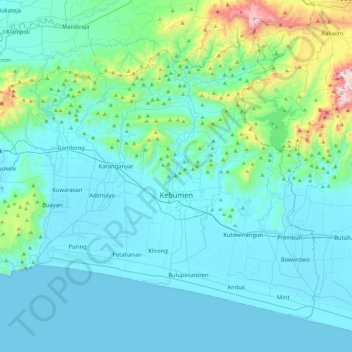
Nom : Carte topographique Kebumen, altitude, relief.
Lieu : Kebumen, Central Java, Java, Indonesia (-7.83021 109.37963 -7.45778 109.83902)
Altitude moyenne : 119 m
Altitude minimum : -1 m
Altitude maximum : 1 015 m
Autres cartes topographiques
Cliquez sur une carte pour visualiser sa topographie, son altitude et son relief.
Ungaran
Indonesia > Central Java > Kabupaten Semarang
Ungaran (Dutch: Oengaran) is a town and adjacent areas in Central Java Province of Indonesia. The town serves as the administrative centre of the Semarang Regency in that province. Ungaran is located at -7° 8' 17", 110° 24' 18" at an elevation of 319 metres. It encompasses two districts (kecamatan) within…
Altitude moyenne : 399 m
Karimunjawa National Park
The geological formation in the archipelago is mostly dominated by quartz sandstone, gravel, mud, and clay. The topography of Karimunjawa Marine National Park is a wave of low land, with elevation ranging from 0–506 meters above sea level. Gajah hill is the Park’s highest point. Temperatures range from…
Altitude moyenne : 1 m
Semarang
Semarang is located on the northern coast of Java. The city of Semarang is one of the important cities located on the north coast of Java and as the main hub connecting Jakarta and Surabaya, and cities in the southern interior of Java Surakarta and Yogyakarta. Semarang City has a height ranging from 2 m (6.6…
Altitude moyenne : 88 m
Cilacap
Indonesia > Central Java > Cilacap > Kelurahan Sidanegara Kecamatan Cilacap
Altitude moyenne : 18 m