
Carte topographique Kriváň
Carte interactive
Cliquez sur la carte pour afficher l’altitude.
À propos de cette carte
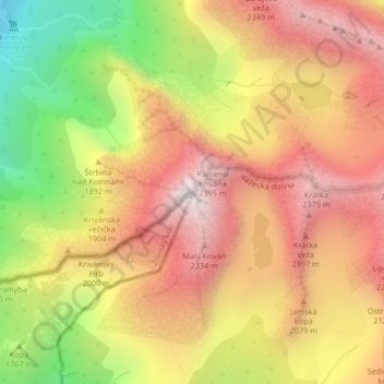
Nom : Carte topographique Kriváň, altitude, relief.
Altitude moyenne : 1 913 m
Altitude minimum : 1 204 m
Altitude maximum : 2 445 m
The relative elevations of the two mountains were determined by the English natural historian Robert Townson, who ascended both peaks in August 1793 and also made an early recorded comment on Kriváň's aesthetic appeal:
Autres cartes topographiques
Cliquez sur une carte pour visualiser sa topographie, son altitude et son relief.
Gerlachovský štít
Slovakia > Region of Prešov > District of Poprad > Vysoké Tatry
Gerlachovský štít, Vysoké Tatry, District of Poprad, Region of Prešov, Eastern Slovakia, 059 84, Slovakia
Altitude moyenne : 2 103 m